Karte Des Handelsgebiets von West - Aequatoreal - Afrika....


 Maps, plans and nautical charts
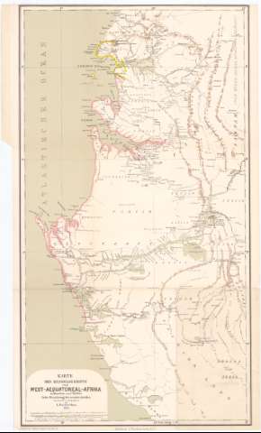
Karte Des Handelsgebiets von West - Aequatoreal - Afrika. Unter Benutzung der neuslen Quellen (1878<(Hamburg< : L. Friederichsen))
Maps, plans and nautical charts
Karte Des Handelsgebiets von West - Aequatoreal - Afrika. Unter Benutzung der neuslen Quellen (1878<(Hamburg< : L. Friederichsen))
 Disponible Holdings
 Section: Maps, plans and nautical charts
Uniform title: GABON. Mapas generales (1878). 1:780000
Title: Karte Des Handelsgebiets von West - Aequatoreal - Afrika. Unter Benutzung der neuslen Quellen / bearbeilet U. autographirt von L. Friederichsen
Material or type of resouce Area: Escala 1:780000 (E8°50'-E11°0'/N2°55').)
Publication: Hamburg : Autogr. Druck V.J. Kohler, 1878<(Hamburg< : L. Friederichsen)
Physical description: 1 mapa : col. ; 65x36 cm en h. de 67x39 cm
Content type: Imagen cartográfica
Media type: computadora
Carrier type: recurso en línea
Notes: Escalas graficas de 10 millas alemanas de 15 al grado [= 9,5 cm] y '40 Nautische M 60 = 1° [= 9,5 cm].
Relieve representado por normales
Tabla de signos convencionales para indicar puntos de población y territorios españoles y franceses
Other authors: Friederichsen, Ludwing F
Koehler, Joham David
UDC: 912:325.4(672.1)'1878'
672.1
Type of publication:
Maps
Rights:
Préstamo:
Disponible
