Accurate situations Carte von einem theile des...


 Maps, plans and nautical charts
Accurate situations Carte von einem theile des Churfurstenthums Sachsen, und haupt saechlich von den Gegenden 4 bis... (176-?)
Maps, plans and nautical charts
Accurate situations Carte von einem theile des Churfurstenthums Sachsen, und haupt saechlich von den Gegenden 4 bis... (176-?)
 Disponible Holdings
 Section: Maps, plans and nautical charts
Uniform title: ALEMANIA. SE. Mapas generales (176-?). 1:25000
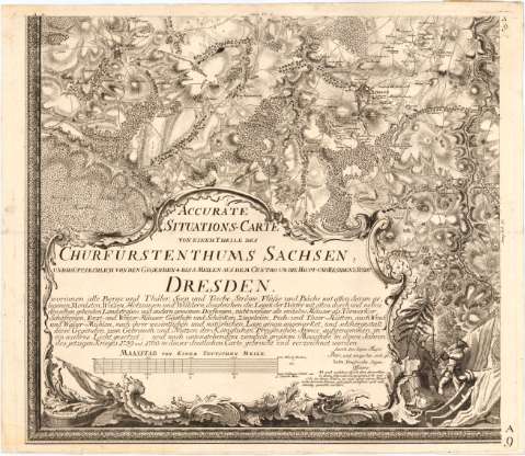
Title: Accurate situations Carte von einem theile des Churfurstenthums Sachsen, und haupt saechlich von den Gegenden 4 bis 5 Meilen aus dem Centro um die Hanpt - und Residenz - stadt Dresden / Petri ; J.D. Schleuen fec. Berolini
Material or type of resouce Area: [Ca. 1:25000], 200 Rhein Ruthen [= 22 cm]
Publication: [Dresden? : [Editor no identificado], 176-?]
Physical description: 1 mapa en 12 h. ; 169,8 x 264 cm en h. de 56,6 x 66 cm
Content type: Imagen cartográfica
Media type: computadora
Carrier type: recurso en línea
Notes: Comprende, al parecer, una parte del antiguo Electorado de Sajonia que comprende un radio de 4 ó 5 millas desde Dresden
Escala gráfica de 10000 "Ordinaire Schritt" [= 22 cm] y 1 "Teutsche Meile" [= 22 cm]
Relieve representado por normales y sombreado
Leyenda explicativa sobre campamentos, sitios y la guerra entre 1759 y 1760
Indica núcleos de población, cultivos, masas forestales, caminos, fortificaciones y el curso de los ríos con flechas
Título, leyenda y escala enmarcadas en cartela barroca con representaciones humanas y útiles bélicos
Sello en seco del Depósito General de la Guerra
Materia / lugar / evento: Mapas generales
Fortificaciones
Guerras
Siglo XVIII
Sajonia
Dresde
Alemania
Other authors: Petri, Isaak Jakob von, 1701-1777
Berolini
Schleuen, J.D
UDC: 912:623.2](430-12)'1760/1769'
(430-328 Dresden)
(430 Dresden)
Type of publication:
Maps
Rights:
Préstamo:
Disponible
