Karte von Berlin und ungebund]


Section: Maps, plans and nautical charts
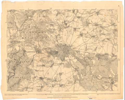
Uniform title: BERLIN (Alemania). Mapas generales. 1819 (1817-1818). 1:51000
Title: Karte von Berlin und ungebund] / Gezeichnet von dem CapFu Westin den Lieuts Fige ; Roel ; Beckey ; schutz und Jug Geogr. Wolff ; Aufgenomen unter Leitung des Major Deckerdurch du Lieut Feige ; Roel ; Becky ; etal Solviati Hartwich u Zulow Grulutticham un dem Ing Geogr Wolff
Material or type of resouce Area: Escala [Ca. 1:51.000], 1 meile o der 2000 Brandenb Rutheu [= 8 cm] ; [proyec conico]
Publication: Berlin : Lithographen Beleke vofs und schwartzkopff, 1818
Physical description: 1 mapa en h. ; 44x55 cm en h. de 48x60'5 cm
Content type: Imagen cartográfica
Media type: computadora
Carrier type: recurso en línea
Notes: Titulo propio redactado a partir del contenido del documento
Coordenadas referidas al parecer al meridiano de Hierro (E29°50-E31°15'/N52°40'-N29°45') Red geográfica de 5' en 5'
Relieve representado por normales
Indica campos de cultivo y masas forestales
Procede de la 'Colección Rico y Sinobas' n 108 y 109
Incompleto solo se dispone de las hojas 4 y 5
Materia / lugar / evento: Mapas generales
1818
Other authors: Feige, Lieut
Roel
Becky
Lithographen Beleke (Berlín)
UDC: 912(430-328 Berlin)'1818'
430-328 Berlin
Type of publication:
 Maps
Maps
Rights:
Préstamo:
 Disponible
