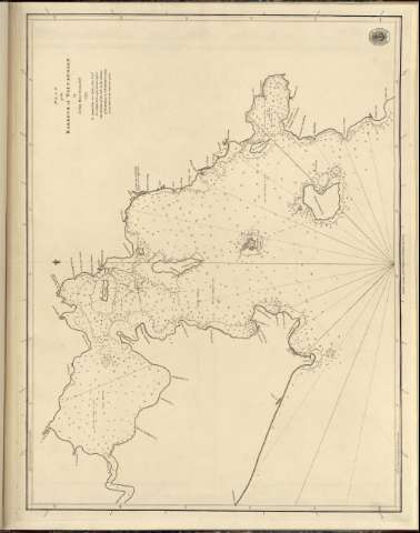
Plan of the Harbour of Tappanooly


Section: Maps, plans and nautical charts
Uniform title: TAPANULI (Indonesia) (Sumatra) (Bahía). Cartas nauticas (1797). Escala [ca. 1:23.000.000]
Title: Plan of the Harbour of Tappanooly / by John Macdonald
Material or type of resouce Area: Escala [ca. 1:23.000.000] (E98°50'-E98°60'/N1°39'-N1°38')
Publication: [London ?] : Published according to Act of Parliament by A Dalrymple, 1797
Physical description: 1 mapa ; 62x46 cm en h. de 66x49 cm
Content type: Imagen cartográfica
Media type: computadora
Carrier type: recurso en línea
Notes: En : 'Chart Red Sea'
Escala grafica hallada a partir de un grado de latitud [= 8 cm]. Orientado con lis en nudo de rumbos
Relieve representado por sondas batimetricas
Indica veriles, bajos y fondeaderos
Nota sobre la profundidad del agua en diferentes estaciones
Sello de Hydrographical office
En : Chart Red Sea
Other authors: Macdonald, John (S.XVIII)
Dalrymple, Alexander
UDC: 912:[551.46:627.22:627.231](26.04 Tapanuli)(Indonesia Sumatra)'1797'
(26.04 Tapanuli)(Indonesia, Sumatra)
Type of publication:
 Maps
Maps
Rights:
Préstamo:
 Disponible
