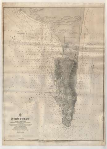
Gibraltar


Section: Maps, plans and nautical charts
Uniform title: Gibraltar. Cartas náuticas. 1886 (1885). 1:12140
Title: Gibraltar / Surveyed by Captain P. Aldrich ; assisted by Lieutts. A. Havergal... [et al.] ; Engraved by Edwd. Weller
Material or type of resouce Area: Escala 1:12.140
Publication: London : James Wyld. Geographer to de Queen 11 & 12 charing cross, S.W. & 2 Royal Exchange E.C., [1886?]
Physical description: 1 carta náutica ; 69x50 cm
Content type: Imagen cartográfica
Media type: computadora
Carrier type: recurso en línea
Notes: Coordenadas respecto al meridiano de Greenwich
Orientado al N y N. magnético. Variación 17 10'W
Relieve representado por normales
Batimetría. Veriles
Indicados los faros en amarillo y rojo
Indicada la composición de los fondos marinos
Precede al título, sello de: 'Hydrographic office', debajo del mismo: 'Price Eighteenpence'
Debajo de la mención de responsabilidad: 'H.M.S. Sylvia, 1885'
Figuran los datos de edición al pie del documento sobre un papel pegado
Reproducción digital. Madrid : Ministerio de Defensa. Archivo General Militar de Madrid
Materia / lugar / evento: Cartas náuticas
Planos de población
1885
Gibraltar
Other authors: Aldrich, Edward
Havergal, A
Weller, Edward
Wyld, James, 1812-1887
UDC: 468.2
Type of publication:
 Maps
Maps
Rights:
Préstamo:
 Disponible
