[Perfil y elevaciones] : [Proyecto de un cuartel para...


 Maps, plans and nautical charts
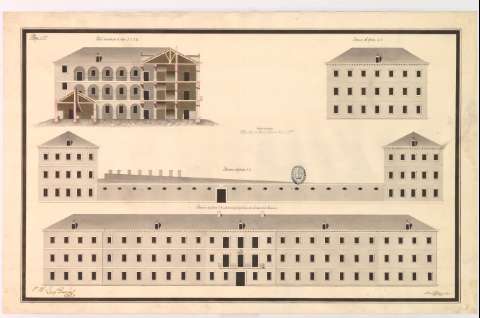
[Perfil y elevaciones] : [Proyecto de un cuartel para Infanteria : Pamplona] (1832?)
Maps, plans and nautical charts
[Perfil y elevaciones] : [Proyecto de un cuartel para Infanteria : Pamplona] (1832?)
 Disponible Holdings
 Section: Maps, plans and nautical charts
Uniform title: Pamplona. Cuarteles (1832). 1:147
Title: [Perfil y elevaciones] : [Proyecto de un cuartel para Infanteria : Pamplona] / Manuel Peralta lo dibujó
Material or type of resouce Area: Escala [ca. 1:147], 50 pies [= 9,5 cm]
Publication: [1832?]
Physical description: 1 plano : ms., col., montado sobre tela ; 53x85,2 cm. en h. de 58,3x91,9 cm
Content type: Imagen cartográfica
Media type: computadora
Carrier type: recurso en línea
Notes: Título facticio
Manuscrito firmado y rubricado. 'V.B. Josef Parreño', con firma y rúbrica
Manuscrito a plumilla en tinta negra, iluminado a la acuarela en negro, gris, amarillo y carmín
Figuran 1 perfil y 3 elevaciones
En el ángulo superior izquierdo: 'Pliego n 3'
Se dispone además del SH+1983/NA-G-16/5 y SH+1983/NA-G-16/6 que corresponden a las plantas
Reproducción digital. Madrid : Ministerio de Defensa. Archivo General Militar de Madrid
Materia / lugar / evento: Proyectos
Navarra (Comunidad Autónoma)
Other authors: Peralta, Manuel
UDC: 465.11 Pamplona
Type of publication:
Maps
Rights:
Préstamo:
Disponible
