Praefectura kircubriensis, quae Gallovidiae maxime...


 Maps, plans and nautical charts
Praefectura kircubriensis, quae Gallovidiae maxime orientalis pars est = The Stewartrie of Kircubright, The most...
- Pont, Timothy, s. XVII
Maps, plans and nautical charts
Praefectura kircubriensis, quae Gallovidiae maxime orientalis pars est = The Stewartrie of Kircubright, The most...
- Pont, Timothy, s. XVII
 Disponible Holdings
 Section: Maps, plans and nautical charts
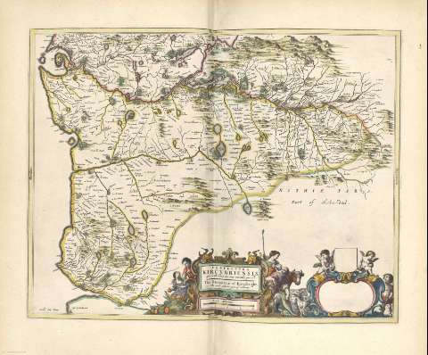
Title: Praefectura kircubriensis, quae Gallovidiae maxime orientalis pars est = The Stewartrie of Kircubright, The most easterlie part of Galloway / Auct. Tim. Pont
Author: Pont, Timothy, s. XVII
Other titles: The Stewartrie of Kircubright, The most easterlie part of Galloway
Material or type of resouce Area: Escala [ca. 1:120000].
Physical description: 1 mapa : il., col. ; 43 x 55 cm
Content type: Imagen cartográfica
Media type: computadora
Carrier type: recurso en línea
Notes: Comprende la zona oriental de la antigua región de Gallloway, en la actualidad distrito, desde al río Dee al occidente
Pie de imprenta tomado de la portada del atlas al que pertenece
Escala gráfica de 4 millas, habiéndose considerado para su cálculo la milla escocesa [= 7,5 cm]. Mención de los puntos cardinales en los márgenes
Orografía de perfil
Límites de la región destacados en color
Título y escala enmarcados en doble cartela barroca, decorada con motivos costumbristas y angelotes. Una parte de la misma aparece sin información
Orientado con el N. al E. de la hoja
Relieve por montes de perfil y sombreado
Arbolado
Ciudades representadas por conjuntos de edificaciones
Costas sombreadas con un fino rayado
Fecha de publicación tomada de la obra en la que se encuentra el mapa
Copia digital. Madrid : Ministerio de Cultura, 2010
Other titles: En: Nuevo Atlas de los Reynos de Escocia e Yrlanda. - Amstelaedami : Apud Ioannem Blaeu, 1654. - [14]
Materia / lugar / evento: Mapas generales
1654
Galloway
Dumfries y Galloway
Escocia
Other authors: Blaeu, Joan, 1596-1673
Related titles: GALLOWAY (Reino Unido) (Escocia). Mapas generales (1654). 1:120000
UDC: 912(1-2/-5)(411)"1654"
(414.92 Galloway)
Type of publication:
Maps
Préstamo:
 Disponible sólo para consulta en sala
