American Atlantic ports-north sheet


 Maps, plans and nautical charts
American Atlantic ports-north sheet (1922)
- Philip, George, 1870-1937
Maps, plans and nautical charts
American Atlantic ports-north sheet (1922)
- Philip, George, 1870-1937
 Disponible Holdings
 Section: Maps, plans and nautical charts
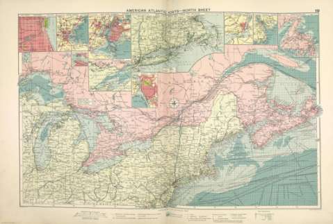
Title: American Atlantic ports-north sheet
Author: Philip, George, 1870-1937
Material or type of resouce Area: Escala 1:5.000.000
Publication: [London] ; [Lierpool] : George Philip & Son, Ltd : The London Geographical Institute : Philip, Son & Nephew, [1922]
Physical description: 1 mapa ; 49 x 72 cm
Content type: Imagen cartográfica
Media type: computadora
Carrier type: recurso en línea
Notes: Copia digital. Madrid : Ministerio de Cultura, 2010
Inserta: Chicago ; Boston Harbour ; New York Harbour ; "Soo" canals ; Continuation of Lake Superior ; The coast from New York to Boston ; Buffalo; Montreal ; Halifax ; Newfoundland
Other titles: En: Philip's Mercantile Marine Atlas. - [London] : Edited by George Philip [et al.], 1922. - Mapa 25
Materia / lugar / evento: Rutas marítimas - Mapas
Puertos - Estados Unidos - Mapas
Puertos - Canadá - Mapas
Grandes Lagos - Mapas
Genre / form: Cartas náuticas
Other authors: George Philip & Son
Merchant, Shippers, Exported and Ocean Travelles
London Geographical Institute
Related titles: Noreste de Estados Unidos. Mapas generales. ca. 1922
CANADÁ. Mapas generales. ca. 1922
UDC: (71)
(74)
Type of publication:
Maps
Préstamo:
 Disponible sólo para consulta en sala
