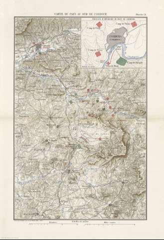
Carte du Pays au Sud de Cordoue


 Disponible Holdings
 Section: Maps, plans and nautical charts
Title: Carte du Pays au Sud de Cordoue / gravé par E. Guillot
Author: Guillot, E
Material or type of resouce Area: Escala 1:160000
Publication: [París] : Imprimerie Nationale, [1887]
Physical description: 1 mapa : col. ; 42 x 28 cm en h. de 52 x 35 cm, pleg. en 26 x 35 cm
Content type: Imagen cartográfica
Media type: computadora
Carrier type: recurso en línea
Notes: Escala gráfica además en "Kilométres" y "Milles romains"
Relieve representado por curvas de nivel y sombreado
Inserta: Travaux d'approche du pont de Corduba. Escala 1:44400
Copia digital. España : Ministerio de Cultura y Deporte. Subdirección General de Coordinación Bibliotecaria, 2010
Other titles: En: Histoire de Jules César : Guerre Civile : Planches : [atlas]. - París : Imprimerie Nationale, 1887. - Planche 24
Materia / lugar / evento: Batallas
Guerra
Itinerarios
Guerras
Estrategia
S.II a.C
Córdoba
Andalucía
Other authors: Francia. Imprimerie Royale
Related titles: Córdoba (Provincia). Batallas. 1887 (53-44 a.C). 1:160.000
UDC: (460.351 Córdoba)
Type of publication:
 Maps
Maps
Rights:
