América central y Las Antillas


Section: Maps, plans and nautical charts
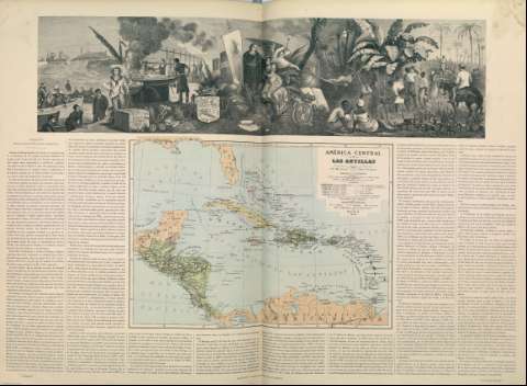
Title: América central y Las Antillas / Dibujado por J.P. Morales ; Grabado por Otto Neussel
Author: Morales, José Pilar
Material or type of resouce Area: Escala 1:9.250.000
Physical description: 1 mapa : grab., col.
Content type: Imagen cartográfica
Media type: computadora
Carrier type: recurso en línea
Notes: Márgenes graduados
Dibujados meridianos y paralelos formando cuadrícula
Meridiano de origen: Madrid
Relieve por normales
Red hidrográfica
Tabla de signos convencionales para indicar poblaciones diferenciando la densidad de población, límites de estados o repúblicas, provincias o confederación y de tribus, cable submarino, arzobispado y obispado
Relación de las posesiones europeas indicadas por clave cromática
En la parte superior un grabado en el que se entremezclan en medio de un paisaje vegetal diferentes escenas relaccionadas con el territorio representado, tales como el descubrimiento de América, comercio del tabaco y escenas de indígenas trabajando en campos
Copia digital. Madrid : Ministerio de Cultura, 2010
Other titles: En: Atlas Geográfico Universal. - Madrid : Editores Astort Hermanos, 1877. - [Mapa 12]
Other authors: Neussel, Otto
Related titles: AMERICA CENTRAL. Mapas generales. 1877
Antillas. Mapas generales. 1877
UDC: (728)
(729)
Type of publication:
 Maps
Maps
