Länder der Ungarischen Krohe : Ungarn, Siebenbürgen,...


 Maps, plans and nautical charts
Länder der Ungarischen Krohe : Ungarn, Siebenbürgen, Slavonien und ein Theil von Kroatien : [generalkarte] (1879)
Maps, plans and nautical charts
Länder der Ungarischen Krohe : Ungarn, Siebenbürgen, Slavonien und ein Theil von Kroatien : [generalkarte] (1879)
 Disponible Holdings
 Section: Maps, plans and nautical charts
Uniform title: Europa central. Mapas generales. 1879. 1:1850000
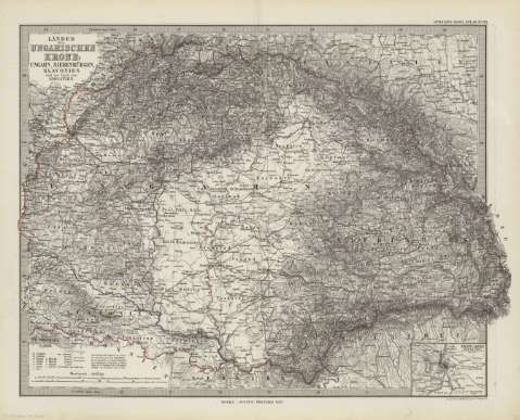
Title: Länder der Ungarischen Krohe : Ungarn, Siebenbürgen, Slavonien und ein Theil von Kroatien : [generalkarte] / Gest. von W. Alt ; Berge von C. Jungmann
Material or type of resouce Area: Escala 1:1.850.000
Publication: Gotha [Alemania] : Justus Perthes, 1879
Physical description: 1 mapa : col. ; 33x41 cm, en h. de 39x48 cm, pleg. en 39x24 cm
Content type: Imagen cartográfica
Media type: computadora
Carrier type: recurso en línea
Notes: Coordenadas : E35 05'-E43 00'/N49 40'-N44 20'. Meridiano de Ferro. Constan ademas coordenadas segun el meridiano de París
Relieve : sombreado
Leyenda de signos utilizados
Inserta : "Pest - Ofen". - Escala 1:50.000
En el margen superior derecho : "Stieler's Hand-Atlas Nº 29"
Copia digital . España : Ministerio de Cultura y Deporte. Subdirección General de Coordinación Bibliotecaria, 2010
Other titles: En: Hand atlas : über alle Theile der Erde und über das Weltgebäude. - Gotha [Alemania R.D.] : Justus Perthes, [1879]. - N 29
Materia / lugar / evento: Mapas generales
Croacia
Eslovenia
Hungría
Yugoslavia
Other authors: Alt, Wilhelm, -1865
Jungmann, Carl
Stieler, Adolf, 1775-1836
Justus Perthes (Firma)
UDC: 912:341.222(439-2/5+497.1-2/5)'1879'
439
497.1
Type of publication:
Maps
Rights:
