Carte Générale de la Gaule


 Maps, plans and nautical charts
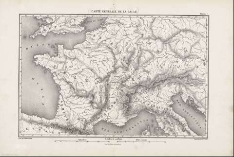
Carte Générale de la Gaule (188-)
- Erhard Schièble, Georges, 1821-1880
Maps, plans and nautical charts
Carte Générale de la Gaule (188-)
- Erhard Schièble, Georges, 1821-1880
 Disponible Holdings
 Section: Maps, plans and nautical charts
Title: Carte Générale de la Gaule / gravé par Erhard Schiéble
Author: Erhard Schièble, Georges, 1821-1880
Material or type of resouce Area: Escala 1:4200000
Publication: [París] : Henri Plon Editeur, rue Garanciére 10, [188-]
Physical description: 1 mapa ; 27x42 cm, en h. de 36x54 cm, pleg. en 36x27 cm
Content type: Imagen cartográfica
Media type: computadora
Carrier type: recurso en línea
Notes: Escala gráfica además en 'Milles romains' y 'Kilométres'. Coordenadas : O9030'-E15 30'/N51 35'-N41 50'. Meridiano de París
Relieve : sombreado
Copia digital. España : Ministerio de Cultura y Deporte. Subdirección General de Coordinación Bibliotecaria, 2010
Other titles: En: [Histoire de Jules César] [atlas]. - [Paris : Henri Plon, Editeur, rue Garanciére 8, 10, 188-]. - Planche 1
Related titles: Europa. Mapas físicos. 188 (499 a.C-476). 1:4200000
UDC: 912:911.2](44+45+430.1+493+492+494)'-0499/0476'
44
45
430.1
(494)
493
492
Type of publication:
Maps
Rights:
