[América Central]


Section: Maps, plans and nautical charts
Uniform title: AMERICA CENTRAL. Cartas náuticas (1740). 1:2000000
Title: [América Central]
Material or type of resouce Area: Escala [ca. 1:20000000], un grado de latitud [= 6,7 cm]
Publication: 1740
Physical description: 1 carta náutica : ms., col., montado sobre tela ; 60,1 x 93,9 cm
Content type: Imagen cartográfica
Media type: computadora
Carrier type: recurso en línea
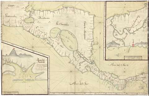
Notes: Presenta desde el volcán de Sacatepeque (Guatemala) a Portobelo (Panamá)
Título propio redactado a partir del contenido del documento
Coordenadas referidas al meridiano de Tenerife (E 283°00'-E 296°50'/N 16°30'-N 7°50'). Orientado con 2 medias lises y 6 nudos de 36 vientos prolongados
Relieve de perfil
Indica veriles, bajos y fondeaderos
Fecha de ejecución tomada de: "Cartografía y Relaciones Históricas de Ultramar". Tomo IV. América Central. 1990
Señala ríos, caminos y principales núcleos de población
Inserta: "Puerto del Realexo : Situado en la Costa del S. por la latd. de 12 gros 10 ms. y por la longd. de 287 grs. 46 ms. segun thenerife". Escala [ca. 1:67000], una legua de 20 al grado [= 8,3 cm]. Indica sondas batimétricas ; "Plano del Istuno de Panama". Escala [ca. 1:278000], cinco leguas de 20 al grado [= 10 cm]. Orientado con media lis.
Materia / lugar / evento: Cartas náuticas
Puertos
Volcanes
Ríos
Caminos
Núcleos de población
1740
América Central
UDC: 728
Type of publication:
 Maps
Maps
Rights:
Préstamo:
 Disponible
