Karte der Nordlichen Hemisphare innerhalb des 40...


 Maps, plans and nautical charts
Karte der Nordlichen Hemisphare innerhalb des 40 Breitengrades = map of the Northern Hemisphere within the 40th... (1855)
Maps, plans and nautical charts
Karte der Nordlichen Hemisphare innerhalb des 40 Breitengrades = map of the Northern Hemisphere within the 40th... (1855)
 Disponible Holdings
 Section: Maps, plans and nautical charts
Uniform title: Mundo. Mapas climáticos (1855). 1:22000000
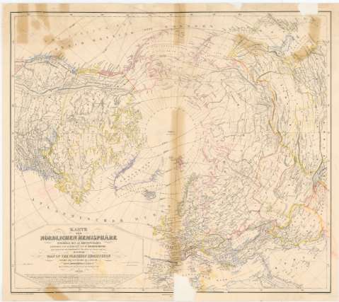
Title: Karte der Nordlichen Hemisphare innerhalb des 40 Breitengrades = map of the Northern Hemisphere within the 40th Degree of Latitude / Entworfen und Bearbeitet von Dr. Heinrich Kiepert ; Nebst Darstellung der Warmeverbreitung fuer Januar, Juli und das Jahr von H.W. Dove ; H. Mahlmann, Geo - Lith.
Material or type of resouce Area: Escala [ca. 1:22000000 ; proyec. equivalente] (O180°-E180°/N90°-N30°)
Publication: Berlin : Bei Dietrich Reimer, 1855 (Berlin : Druck der Lith. Anst. V.A. Dettmers)
Physical description: 1 mapa : col., montado sobre tela ; 57x64,8 cm
Content type: Imagen cartográfica
Media type: computadora
Carrier type: recurso en línea
Notes: Comprende Europa, Asia, y América del Norte
Escala hallada a partir de un grado de latitud [= 0,5 cm]. Red geográfica de 10° en 10°
Relieve representado por normales
Tabla de signos convencionales para indicar líneas isotermas
Other authors: Kiepert, Heinrich
Dettmers, A
Dove, Heinrich Wilhelm
Mahlmann, Heinrich
Reimer, Dietrich
UDC: 912:551.524(100)'1855'
(98)
Type of publication:
Maps
Rights:
Préstamo:
Disponible
