Sketch showing the position of the Union and Rebel Forces...


 Maps, plans and nautical charts
Sketch showing the position of the Union and Rebel Forces as situated on the 30th of november, 1863 in the vicinity... (189-?)
Maps, plans and nautical charts
Sketch showing the position of the Union and Rebel Forces as situated on the 30th of november, 1863 in the vicinity... (189-?)
 Disponible Holdings
 Section: Maps, plans and nautical charts
Uniform title: ORANGE (Estados Unidos, Virginia) (Distrito). Operaciones bélicas. 189 (1863). 1:27277
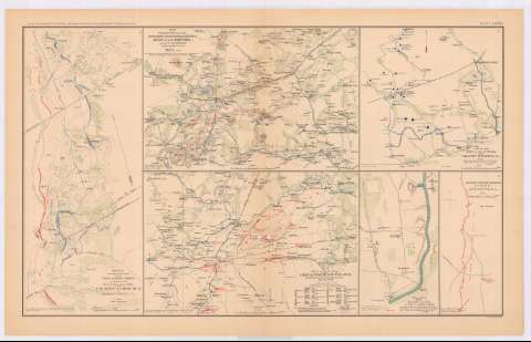
Title: Sketch showing the position of the Union and Rebel Forces as situated on the 30th of november, 1863 in the vicinity of Mine Run, in Orange County, VA.
Material or type of resouce Area: Escala [ca. 1:27277], 1 mile [= 5,9 cm]
Publication: Washington : Government Printing Office, [189-?] (N.Y. [Nueva York] : Julius Bien & co.)
Physical description: 1 mapa : col. ; 18x42 cm, en h. de 47x75 cm
Content type: Imagen cartográfica
Media type: computadora
Carrier type: recurso en línea
Notes: En : Atlas to accompany the Official Records of the Union and Confederate Armies 1861-1865. - Plate LXXXVII, n 1
Relieve : curvas de configuración
Orientado con flecha
Figuran representadas con distintos colores las fuerzas de los dos ejércitos
Mapa original en posesión de : Maj. Gen. George G. Meade
Figura en margen inferior izquierdo : Series 1. Vol XXIX
En : Atlas to accompany the Official Records of the Union and Confederate Armies 1861-1865
Materia / lugar / evento: Guerra civil
Operaciones bélicas
Estrategia militar
Baterías
Artillería de campaña
Líneas ferroviarias
Carreteras
1863
Estados Unidos
UDC: 912:355.4]:[355.43+623.1+623.413+625.1+625.7](755 Orange Conty)'1863'
755 Orange County
Type of publication:
Maps
Rights:
Préstamo:
Disponible
