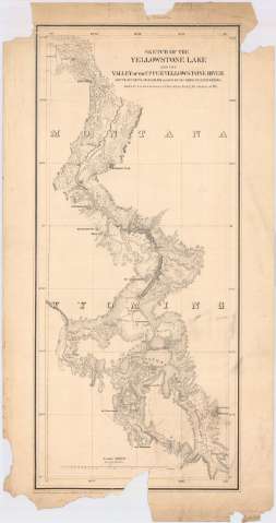
Sketch of the Yellowstone Lake, and the Valley of the...


 Maps, plans and nautical charts
Sketch of the Yellowstone Lake, and the Valley of the upper Yellowstone River (1871?)
Maps, plans and nautical charts
Sketch of the Yellowstone Lake, and the Valley of the upper Yellowstone River (1871?)
 Disponible Holdings
 Section: Maps, plans and nautical charts
Title: Sketch of the Yellowstone Lake, and the Valley of the upper Yellowstone River / route of Capt's J.W. Barlow and D.P. Heap corps of engineers in their reconnoissance of the that region during the summer of 1871 ; engraved at Headquarters Corps of Engineers War Departament
Material or type of resouce Area: Escala 1:500000 (O 111°00'--O 110°00'/N 45°45'--N 44°00')
Publication: [Washington? : Headquarters Corps of Engineers War Department?, 1871?]
Physical description: 1 mapa ; 70 x 30 cm
Content type: Imagen cartográfica
Media type: computadora
Carrier type: recurso en línea
Notes: Comprende la parte noroccidental del estado norteamericano de Wyoming
Escala también dada en forma gráfica de 1 pulgada
Relieve por normales. Isolíneas batimétricas
Other authors: Barlow, J.W
Heap, D.P
Estados Unidos. Army. Corps of Engineers
UDC: 787.16
Type of publication:
Maps
Rights:
Préstamo:
Disponible
