Bab Tasa : Yebala. H. 09-7


 Maps, plans and nautical charts
Bab Tasa : Yebala (1941)
- España. Servicio Geográfico del Ejército
Maps, plans and nautical charts
Bab Tasa : Yebala (1941)
- España. Servicio Geográfico del Ejército
 Disponible Holdings
 Section: Maps, plans and nautical charts
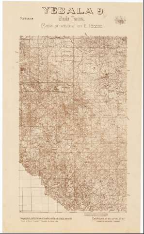
Title: Bab Tasa : Yebala. H. 09-7
Material or type of resouce Area: Escala 1:50.000 ; proyec. policéntrica, cuadrícula en cónica secante
Publication: [Madrid] : Talleres del Servicio Geográfico y Cartográfico del Ejercito, 1941
Physical description: 1 h. : montado en tela ; 53 x 32 cm
Content type: Imagen cartográfica
Media type: computadora
Carrier type: recurso en línea
Notes: En margen superior: Gráfico de localización de la hoja
Levantado por fotogrametría y taquimetría
Margen inferior graduado. - Mapa en cuadrícula. - Relieve representado por curvas de nivel, equidistancia 20 metros y puntos acotados. - Arbolado. - Hidrografía. - Red de carreteras y caminos. - Toponimia. - Representación de núcleos urbanos, edificaciones aisladas y santuarios. - Divisiones administrativas
Este octavo no comprende la totalidad del territorio de esta región correspondiente al Protectorado Español a causa de no haberse podido realizar con anterioridad a la fecha de su publicación, las operaciones de levantamiento topográfico que se hallan pendientes de la delimitación de las dos zonas, Española y Francesa
Other titles: En: Marruecos : Mapa provisional en E. 1:50.000. - 2ª ed.. - [Madrid] : Servicio Geográfico del Ejército, 1934-1953. - H. 09-7
Materia / lugar / evento: Marruecos - Historia - 1912-1956 (Protectorado español) - Mapas
Bab Taza - Mapas
Genre / form: Mapas topográficos
UDC: (64 Yebala)
Type of publication:
Maps
Rights:
Préstamo:
Disponible
