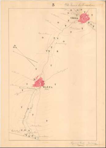
Itinerario topográfico de Jaen á Las Correderas por Baeza...


 Maps, plans and nautical charts
Itinerario topográfico de Jaen á Las Correderas por Baeza y Ubeda (1852)
Maps, plans and nautical charts
Itinerario topográfico de Jaen á Las Correderas por Baeza y Ubeda (1852)
 Disponible Holdings
 Section: Maps, plans and nautical charts
Uniform title: JAÉN. Mapas itinerarios. Español (1852). 1:20.000
Title: Itinerario topográfico de Jaen á Las Correderas por Baeza y Ubeda / ejecutado por los Capitanes del Cuerpo E.M. D. Miguel del Trell y D. Francisco Sanchez
Material or type of resouce Area: Escala [1:20.000]
Publication: 1852
Physical description: 1 mapa en 6 h. : ms., col. ; en h. de 69,8 x 50,6 cm
Content type: Imagen cartográfica
Media type: computadora
Carrier type: recurso en línea
Notes: Comprende parte de las términos municipales de Mancha Real, Baeza, Úbeda, Arquillos, Las Correderas y la ciudad de Jaén
Título y mención de responsabilidad tomados de la hoja que agrupa a los que conforman este itinerario
Manuscritos firmados y rubricados por los autores
Orientados al norte geográfico y magnético
Relieve representado por curvas de nivel
Mención del número de vecinos de los núcleos de población más significativos
Other titles: Documento relacionado: Trell y Chacón, Miguel del. Itinerario de Jaén a las Correderas por Baeza y Úbeda
Materia / lugar / evento: Itinerarios topográficos
Úbeda
Baeza
Jaén (Provincia)
Other authors: Trell y Chacón, Miguel del, 1823-1883
Sánchez, Francisco Militar
España. Estado Mayor Central
UDC: (460.352)
Type of publication:
Maps
Rights:
Préstamo:
Disponible
