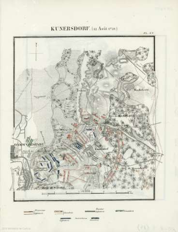
Kunersdorf (12 Aout 1759


Section: Maps, plans and nautical charts
Uniform title: Kunersdorf (Alemania). Batallas. 1839 (1759). Francés. 1:50.000
Title: Kunersdorf (12 Aout 1759
Material or type of resouce Area: Escala 1:50000
Physical description: 1 mapa : col. a mano ; 31x24 cm
Content type: Imagen cartográfica
Media type: computadora
Carrier type: recurso en línea
Notes: Coloreadas las posiciones y movimientos de los combatientes
Materia / lugar / evento: Guerra de los Siete Años, 1756-1763
Operaciones bélicas
Estrategia militar
Topónimos antiguos
1759
Kunersdorf (Alemania)
Europa
Genre / form: Mapas militares
UDC: 912:355.4]:355.43(4-191.2)'1759'
4-191.2
Type of publication:
 Maps
Maps
Rights:
Archivo General Militar de Madrid
Location: PL — Call number: AT-5/15 — Código de barras: 2112744
Préstamo:
 Disponible

© Ministerio de Defensa de España
P. de la Castellana, 109 28071 Madrid.
Tlf: (34) 91 395 50 00
Email: patrimonio.cultural@oc.mde.es