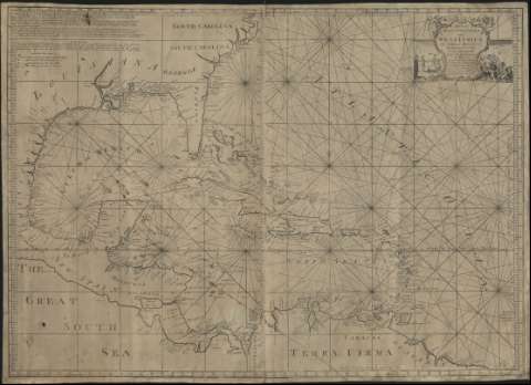
A General Mercators Chart of the West Indies, The Gulph...


 Maps, plans and nautical charts
A General Mercators Chart of the West Indies, The Gulph of Mexico, the Coasts of Carolina Virginia and the Isles of... (1740?)
Maps, plans and nautical charts
A General Mercators Chart of the West Indies, The Gulph of Mexico, the Coasts of Carolina Virginia and the Isles of... (1740?)
 Disponible Holdings
 Section: Maps, plans and nautical charts
Uniform title: Caribe (Mar). Cartas náuticas (1740?). 1:5500000
Title: A General Mercators Chart of the West Indies, The Gulph of Mexico, the Coasts of Carolina Virginia and the Isles of America / By Robt. Waddington ...
Material or type of resouce Area: Scale [ca. 1.5.500.000]. 100 English and French Leagues 20 to a Degree [= 10 cm] ; [proyec. de Mercator]
Publication: London : J. Mount & J. Page, [1740?]
Physical description: 1 carta náutica ; 70 x 98 cm
Content type: Imagen cartográfica
Media type: computadora
Carrier type: recurso en línea
Notes: Coordenadas referidas al meridiano de Londres (O 99º-O 51º/N 37º-N 6º) y meridiano de Kingston (O 22º-E 25º/N 37º-N 6º). Orientado con nudo de rumbos
Relieve representado por sombreado costero y montes de perfil
Indica veriles, bajos y sondas batimétricas
Tabla de signos convencionales para indicar latitud y longitud
Nota explicativa de un sistema para hallar la distancia entre dos puntos
Título enmarcado en cartela barroca con representación de figuras mitológicas
Materia / lugar / evento: Cartas náuticas
Caribe (Mar)
México (Golfo)
Other authors: Waddington, Robert
Jno. Mount and Tho. Page
UDC: 261.65
Type of publication:
Maps
Rights:
Préstamo:
Disponible
