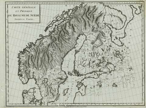
Carte Générale et Physique du Royaume de Suède : premiere...


 Maps, plans and nautical charts
Carte Générale et Physique du Royaume de Suède : premiere Carte (1797 ?)
Maps, plans and nautical charts
Carte Générale et Physique du Royaume de Suède : premiere Carte (1797 ?)
 Disponible Holdings
 Section: Maps, plans and nautical charts
Uniform title: EUROPA. NO. Mapas físicos (1797). 1:4830917
Title: Carte Générale et Physique du Royaume de Suède : premiere Carte / P.F. Tardieu sculp.
Material or type of resouce Area: Escala [ca. 1:4.830.917]. 1 [= 2,3 cm]
Publication: Paris : Chez Mr. Mentelle ..., Rue de Seine Fauxbourg S. Germain ..., [1797 ?]
Physical description: 1 mapa ; 34x49 cm
Content type: Imagen cartográfica
Media type: computadora
Carrier type: recurso en línea
Notes: Coordenadas : O5 -O70 /N70 -N55 . Meridiano de Paris. Coordenadas también del meridiano de Ferro
Márgenes graduados. - Dibujados meridianos y paralelos formando una cuadrícula. - Relieve representado por montes de perfil y sombreado. - Red hidrográfica destacada
Copia digital. España : Ministerio de Cultura. Dirección General del Libro, Archivos y Bibliotecas, 2010
Other titles: En: Atlas nouveau. - Paris : Chez Mr. Mentelle Historiographe de Monseigneur le Comte d'Antois, Rue de Seine Fauxbourg S. Germain, Hotel de Mayence, [1797 ?]
Other authors: Tardieu, Antoine-François, 1757-1822
Mentelle, Edmé, 1730-1815
UDC: 912:911.2]:341.222(485+481+480)'1797'
485
481
480
Type of publication:
Maps
Rights:
Préstamo:
Disponible
