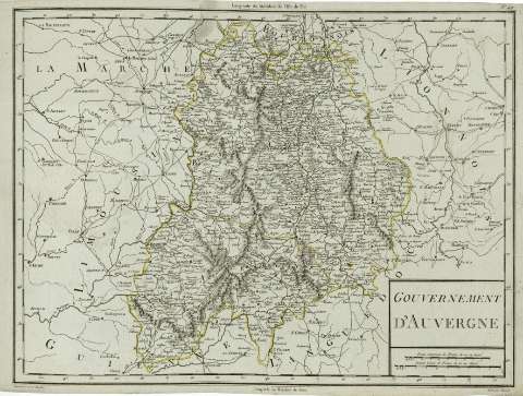
Gouvernement d'Auvergne


Section: Maps, plans and nautical charts
Uniform title: Auvernia (Francia). Mapas generales (1797?). 1:608827
Title: Gouvernement d'Auvergne / gravé par P.F. Tardieu ; ecrit par Herault
Material or type of resouce Area: [Ca. 1:608.827]. 10 lieues communes de France de 20 au Degré [= 7,3 cm]
Publication: Paris : Chez Mr Mentelle ..., Rue de Seine Fauxbourg S. Germain..., [1797?]
Physical description: 1 mapa : col. ; 34 x 49 cm
Content type: Imagen cartográfica
Media type: computadora
Carrier type: recurso en línea
Notes: Márgenes graduados. - Relieve representado por sombreado. - Red hidrográfica. - Red de transportes. - División administrativa delimitada por línea de color. - Toponímia
Copia digital. España : Ministerio de Cultura. Dirección General del Libro, Archivos y Bibliotecas, 2010
Other titles: En: Atlas nouveau. - Paris : Chez Mr. Mentelle Historiographe de Monseigneur le Comte d'Antois, Rue de Seine Fauxbourg S. Germain, Hotel de Mayence, [1797 ?]
Materia / lugar / evento: Mapas generales
Divisiones administrativas
Redes de transporte
Carreteras
Elementos decorativos
Bourbonnais
Lemosín
Francia
UDC: (445.9)
Type of publication:
 Maps
Maps
Rights:
Préstamo:
 Disponible
