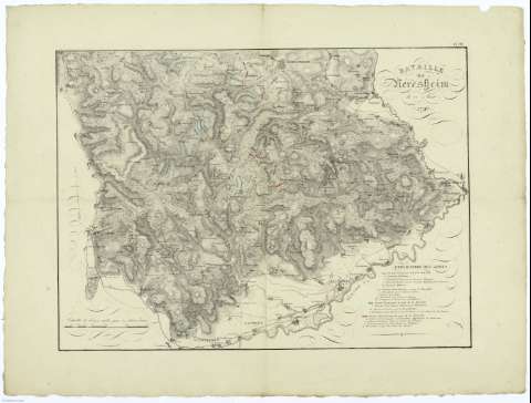
Bataille de Neresheim le 11 Aust 1796


Section: Maps, plans and nautical charts
Uniform title: Neresheim (Alemania, R.F.). Batallas. 18 (1796). 1:1111110
Title: Bataille de Neresheim le 11 Aust 1796 / Ferni Berge
Material or type of resouce Area: Escala [ca. 1:1.111.110] douze mille pas [= 11,2 cm]
Publication: [France ? : [Editor no identificado]], 18..?
Physical description: 1 mapa : col. ; 40x46 cm, en h. de 53x70 cm, pleg. en 26x35 cm
Content type: Imagen cartográfica
Media type: computadora
Carrier type: recurso en línea
Notes: Leyenda explicativa
Coloreadas las posiciones de los ejércitos antes y durante la batalla
En el márgen inferior derecho nombre ilegible
Copia digital. España : Ministerio de Cultura. Dirección General del Libro, Archivos y Bibliotecas, 2010
Other titles: En: [ Atlas de la Campagne de 1796 en Allemagne ]. - [France ?] : [Editor no identificado], [18--?]. - Pl. III
Materia / lugar / evento: Batallas
Maniobras de campaña
Operaciones bélicas
Baden-Württemberg
Baviera
Alemania
Other authors: Ferini, Berge
UDC: 912:355.422]:[355.52:355.4](430.1)'1796'
430.1
Type of publication:
 Maps
Maps
Rights:
Préstamo:
 Disponible
