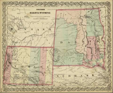
Colton's Dakota and Wyoming


 Maps, plans and nautical charts
Colton's Dakota and Wyoming (1872)
- Colton, G. Woolworth, 1827-1901
Maps, plans and nautical charts
Colton's Dakota and Wyoming (1872)
- Colton, G. Woolworth, 1827-1901
 Disponible Holdings
 Section: Maps, plans and nautical charts
Title: Colton's Dakota and Wyoming / [drawn by George Woolworth Colton]
Author: Colton, G. Woolworth, 1827-1901
Material or type of resouce Area: Escala [ca. 1:3.094.904], 100 statue miles [= 5.2 cm]
Publication: New York : published by G.W. and C.B. Colton & Co., [1872]
Physical description: 1 mapa ; 44 x 36 cm
Content type: Imagen cartográfica
Media type: computadora
Carrier type: recurso en línea
Notes: Indica meridianos de origen: Washington y Greenwich ; Márgenes graduados.
Indica divisiones administrativas marcadas por colores.
Inserta nota: "Boundary Line between the United States and British Territory according the Treaty of 1846".
Copia digital. España : Ministerio de Cultura y Deporte. Subdirección General de Coordinación Bibliotecaria, 2010
Materia / lugar / evento: Mapas políticos
Divisiones administrativas - Mapas
Dakota del Norte (Estados Unidos) - Mapas
Dakota del Sur (Estados Unidos) - Mapas
Wyoming (Estados Unidos) - Mapas
Other authors: G.W. & C.B. Colton & Co
Related titles: ESTADOS UNIDOS. Central. Divisiones administrativas (1872)
UDC: 912:911.2
(783)
(784)
(787)
Type of publication:
Maps
Rights:
