Ireland im maassstabe von 1:1.500.000


 Maps, plans and nautical charts
Ireland im maassstabe von 1:1.500.000 (1879)
- Petermann, Augustus, 1822-1878
Maps, plans and nautical charts
Ireland im maassstabe von 1:1.500.000 (1879)
- Petermann, Augustus, 1822-1878
 Disponible Holdings
 Section: Maps, plans and nautical charts
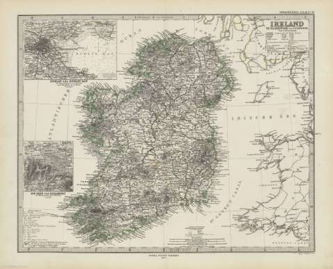
Title: Ireland im maassstabe von 1:1.500.000 / Von A. Petermann ; Poppey u. Jungmann sculp.
Author: Petermann, Augustus, 1822-1878
Material or type of resouce Area: Escala 1:1.500.000 (O12 20'-E3 08'/N55 35'-N51 15')
Publication: Gotha [Alemania] : Justus Perthes, 1879
Physical description: 1 mapa : col. ; 33x41 cm, en h. de 39x48 cm, pleg. en 39x24 cm
Content type: Imagen cartográfica
Media type: computadora
Carrier type: recurso en línea
Notes: Constan ademas coordenadas según el meridiano de París y de Ferro
Relieve : líneas perpendiculares normales
Leyenda de signos utilizados
Inserta : Plano de población de 'Dublin und Dublin Bay'. - Escala 1:150000 ; 'Die Seen von Killarney' [karte]. - Escala 1:200000
En el margen superior derecho : "Stieler's Hand-Atlas Nº 48"
Copia digital . España : Ministerio de Cultura y Deporte. Subdirección General de Coordinación Bibliotecaria, 2010
Other titles: En: Hand atlas : über alle Theile der Erde und über das Weltgebäude. - Gotha [Alemania R.D.] : Justus Perthes, [1879]. - N 48
Materia / lugar / evento: Mapas generales
Planos de población
Irlanda del Norte (Reino Unido)
Dublín
Irlanda
Other authors: Poppey, Carl, 1829-1875
Jungmann, Carl
Stieler, Adolf, 1775-1836
Justus Perthes (Firma)
Related titles: Irlanda. 1:1500000
UDC: 912:341.222(417-2/-5)'1879'
417
912:314(417 Dublin)(084.3)'1879'
Type of publication:
Maps
Rights:
