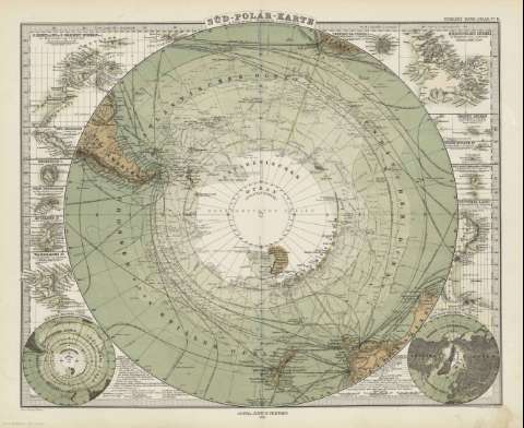
Süd - Polar Karte


 Disponible Holdings
 Section: Maps, plans and nautical charts
Title: Süd - Polar Karte / von a. Petermann ; gez. v. Ernst Debes ; gest v. H. Alt v. Stichart
Author: Petermann, Augustus, 1822-1878
Material or type of resouce Area: Escala 1:40.000.000
Publication: Gotha [Alemania] : Justus Perthes, 1879
Physical description: 1 mapa : col. ; 34x42 cm, en h. de 39x48 cm, pleg. en 39x24 cm
Content type: Imagen cartográfica
Media type: computadora
Carrier type: recurso en línea
Notes: Relieve : líneas perpendiculares normales
Leyenda de signos utilizados
Inserta 14 mapas de detalle
En el margen superior derecho : "Stieler's Hand-Atlas Nº 11"
Copia digital . España : Ministerio de Cultura y Deporte. Subdirección General de Coordinación Bibliotecaria, 2010
Other titles: En: Hand atlas : über alle Theile der Erde und über das Weltgebäude. - Gotha [Alemania R.D.] : Justus Perthes, [1879]. - N 11
Materia / lugar / evento: Descubrimientos geográficos
Mapas generales
Hemisferio Sur
Other authors: Alt, H
Debes, Ernst, 1840-1923
Stieler, Adolf, 1775-1836
Stichart, H.
Justus Perthes (Firma)
Related titles: HEMISFERIO SUR. Mapas fisicos (1879). 1:40000000
UDC: 912:911.2]:910(21)(215-13)'1879'
215-13
Type of publication:
 Maps
Maps
Rights:
