Welt - Karte : zur ubersicht der luft - strömungen und...


 Maps, plans and nautical charts
Welt - Karte : zur ubersicht der luft - strömungen und der see - wege : [Karte] (1879)
- Berghaus, Hermann, 1828-1890
Maps, plans and nautical charts
Welt - Karte : zur ubersicht der luft - strömungen und der see - wege : [Karte] (1879)
- Berghaus, Hermann, 1828-1890
 Disponible Holdings
 Section: Maps, plans and nautical charts
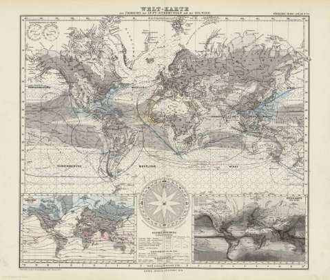
Title: Welt - Karte : zur ubersicht der luft - strömungen und der see - wege : [Karte] / entworfen & gez. v. Herm. Berghaus 1867
Author: Berghaus, Hermann, 1828-1890
Edición: [Ed. 1867], nachtr 1876
Material or type of resouce Area: Escala [ca. 1:20.000.000] (O180 -E180 /N90 -S90)
Publication: Gotha [Alemania] : Justus Perthes, 1879
Physical description: 1 mapa : col. ; 34x38 cm, en h. de 39x48 cm, pleg. en 39x24 cm
Content type: Imagen cartográfica
Media type: computadora
Carrier type: recurso en línea
Notes: Leyenda de signos utilizados
Inserta : Linien gleicher mittlerer Jahres - Warme der luft nach dove - - Regen - Kart der Erde
En el margen superior derecho : "Stieler's Hand-Atlas Nº 6"
Copia digital . España : Ministerio de Cultura y Deporte. Subdirección General de Coordinación Bibliotecaria, 2010
Other titles: En: Hand atlas : über alle Theile der Erde und über das Weltgebäude. - Gotha [Alemania R.D.] : Justus Perthes, [1879]. - N 6
Other authors: Stieler, Adolf, 1775-1836
Justus Perthes (Firma)
Related titles: Mundo. Mapas físicos. 1879 (1867). 1:20000000
UDC: 912:[551.466:551.55](100)'1867'
100
Type of publication:
Maps
Rights:
