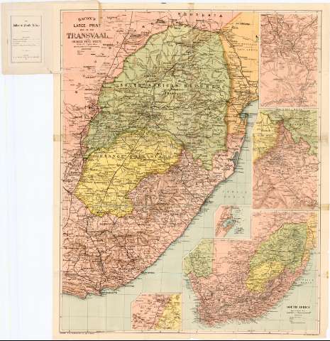
Bacon's Large-Print Map of the Transvaal and Orange Free...


 Maps, plans and nautical charts
Bacon's Large-Print Map of the Transvaal and Orange Free State (1900)
Maps, plans and nautical charts
Bacon's Large-Print Map of the Transvaal and Orange Free State (1900)
 Disponible Holdings
 Section: Maps, plans and nautical charts
Uniform title: AFRICA. SE. Mapas generales (1900). 1:700000
Title: Bacon's Large-Print Map of the Transvaal and Orange Free State
Material or type of resouce Area: [Ca. 1:700000], 30 English Miles [= 7 cm] ; [proyec. ortográfica meridiana] (E 25°-E 36°/S 22°-S 35°)
Publication: London : G.W. Bacon & Co., LTD., 127, Strand, 1900
Physical description: 1 mapa : col. ; 93 x 76,1 cm
Content type: Imagen cartográfica
Media type: computadora
Carrier type: recurso en línea
Notes: Presenta además cinco mapas de detalle
Red geográfica de 1° en 1°
Relieve representado por normales
Tabla de signos convencionales para indicar carreteras y lineas ferroviarias
Other authors: Bacon, George Washington
G.W. Bacon & Co. (Londres)
UDC: 912(6-12)'1900'
6-12
Type of publication:
Maps
Rights:
Préstamo:
Disponible
