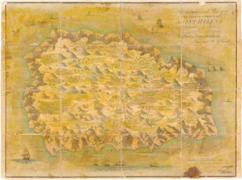
This Geographical Plan of the Island & Forts of Saint...


 Maps, plans and nautical charts
This Geographical Plan of the Island & Forts of Saint Helena is Dedicated by permission to Field Marshal His R.... (1815)
Maps, plans and nautical charts
This Geographical Plan of the Island & Forts of Saint Helena is Dedicated by permission to Field Marshal His R.... (1815)
 Disponible Holdings
 Section: Maps, plans and nautical charts
Title: This Geographical Plan of the Island & Forts of Saint Helena is Dedicated by permission to Field Marshal His R. Highness the Duke of Kent and Strathearn / By Lieu R.P. Read ; Enga. by R. Kirkwood
Material or type of resouce Area: Escala [ca. 1:40000], 2 miles [= 8,7 cm]
Publication: [London ? : [Editor no identificado], 1815]
Physical description: 1 mapa : col., montado sobre tela ; 44x59,3 cm
Content type: Imagen cartográfica
Media type: computadora
Carrier type: recurso en línea
Notes: Orientado con lis en cuadrante
Relieve de perfil
Impreso en papel parafinado
En el ángulo superior derecho reproducción facsimil de la firma de Napoleon Bonaparte como primer Coronel y como Emperador
Indica núcleos de población mediante edificios de perfil y masas forestales
Texto explicativo de la isla al dorso
Representación de navios en el mar
Procede de la 'Colección Rico y Sinobas'
Entelado en 16 cuarterones
Materia / lugar / evento: Mapas generales
1815
Other authors: Read, R.P
Kirkwood, Robert
UDC: 912(699.2 Santa Elena, isla)'1815'
699.2 Santa Elena
Type of publication:
Maps
Rights:
Préstamo:
Disponible
