A New and Correct Chart of the Caribbee or Windward...


 Maps, plans and nautical charts
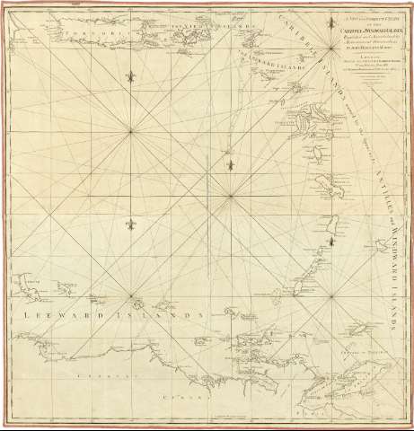
A New and Correct Chart of the Caribbee or Windward Island : Regulated and Ascertained by Astronomical observations (July 27th 1784)
Maps, plans and nautical charts
A New and Correct Chart of the Caribbee or Windward Island : Regulated and Ascertained by Astronomical observations (July 27th 1784)
 Disponible Holdings
 Section: Maps, plans and nautical charts
Uniform title: Pequeñas Antillas. Cartas náuticas. 1784. 1:1.400.000
Title: A New and Correct Chart of the Caribbee or Windward Island : Regulated and Ascertained by Astronomical observations / By John Hamilton Moore
Material or type of resouce Area: Escala [ca. 1:1400000] ; [proyec. Mercator]
Publication: London : Printed for, and Sold by John Hamilton Moore, N° 104, Minories, Tower Hill : and George Robinson, in Pater-moster-Row as the Act directs, July 27th 1784
Physical description: 1 carta náutica ; 78 x 76 cm
Content type: Imagen cartográfica
Media type: computadora
Carrier type: recurso en línea
Notes: Comprende además parte de la costa septentrional de Venezuela
Escala hallada a partir de un grado de latitud [= 7,7 cm]. Coordenadas referidas al meridiano de Londres (O 69°00'-O 59°20'00''/N 18°50'-N 9°00') y Ferro. Red geográfica de 1° en 1°. Orientado con 5 lises
Relieve de perfil
Indica veriles, bajos y sondas batimétricas
Bajo el pie de imprenta aparece: "T.J. Blake fc Nº 12 6re. Wild Street Drury Lone"
Señala bancos de arena y la dirección de las corrientes marinas
Materia / lugar / evento: Cartas náuticas
Costas
Corrientes oceánicas
1784
Venezuela
Other authors: Moore, John Hamilton
Robinson, George G., ed
UDC: 729.7/8
Type of publication:
Maps
Rights:
Préstamo:
Disponible
