An Accurate Map of North and South Carolina With Their...


 Maps, plans and nautical charts
An Accurate Map of North and South Carolina With Their Indian Frontiers : Shewing in a distinct manner all the... (1777)
Maps, plans and nautical charts
An Accurate Map of North and South Carolina With Their Indian Frontiers : Shewing in a distinct manner all the... (1777)
 Disponible Holdings
 Section: Maps, plans and nautical charts
Uniform title: Estados Unidos. Mapas generales (1777). 1:555000
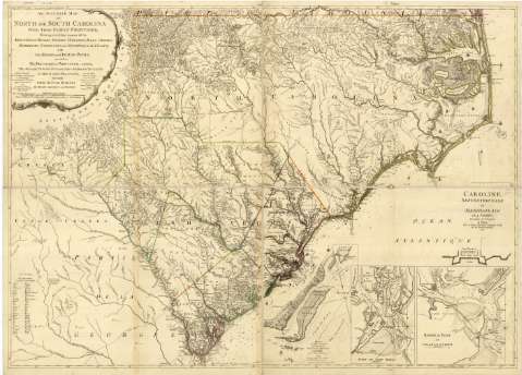
Title: An Accurate Map of North and South Carolina With Their Indian Frontiers : Shewing in a distinct manner all the Mountains Rivers Swamps Marshes Bays Creeks, Harbours Sandbanks and Soundings on the Coast, With the Roads and Indian Paths, as well as The Boundary or Provincial lines, The Several Townships and other divisions of the Land in Both the Provinces, the whole From Actual Surveys / By Henry Mouzon and others = Carte exacte de la Caroline Septentrionale et Meridionale, avec les Frontieres des Indiens : Offrant distinctement toutes les Montagnes, Rivieres, Etangs, Marais, Bayes, Creeks, Ports, Sables, et Sondes avec les Routes et Sentiers des Sauvages ainsi que les limites les Paroisses et autres Divisions, dans les deux Provinces, te tout d'après des Cartes nouvellemt / Levées, Par H. Mouzon et autres
Material or type of resouce Area: Escala [ca. 1:555000] ; [proyec. Mercator]
Publication: Paris : for M. Le Rouge Ingineer Géographer Augustin Street, with Priviledge, 1777
Physical description: 1 mapa : col., montado sobre tela ; 99 x 139 cm
Content type: Imagen cartográfica
Media type: computadora
Carrier type: recurso en línea
Notes: Comprende el E. de Georgia, el S. de Virginia y Carolina del Norte
Escala de 60 millas inglesas de 69 1/2 en grado [= 17,4 cm]. Coordenadas referidas al meridiano de Londres (O 83°50'-O 75°50'/N 36°35'-N 31°55'). Orientado con media lis
Relieve representado por normales
Indica fondeaderos y sondas batimétricas. Clave hidrográfica para determinar la calidad del fondo
Leyenda explicativa sobre las características del terreno
Tabla con traducción de términos ingleses al francés
Figuran delimitadas las circunscripciones administrativas menores del estado de Carolina del Sur mediante líneas de color, así como los barrios de algunas de las ciudades
Señala la dirección de las corrientes marinas
Aparecen dibujos de navíos
Al verso: "Lámina 46", que corresponde a: "Cartografía y Relaciones Históricas de Ultramar". Tomo II. Estados Unidos y Canadá. 1953
En el margen derecho: "Caroline Septentrionale et Meridionale en 4 Fevilles traduite de L'Anglois", con el pie de imprenta en francés
Título propio, mención de responsabilidad y escala enmarcados en cartela decorada con motivos arquitectónicos
Inserta: "Attaques du Fort Sulivan prés Charlestown dans la Caroline Méridionale par les Anglois le 28. Jun. 1776 avec les Camps. des Amériquains". Escala [ca. 1:30359]. Orientado con nudo de rumbos y lis. Indica sondas batimétricas expresadas en brazas ; "Port de Port Royal". Escala [ca. 1:231482]. Orientado con nudo de rumbos y lis ; "Barre et Port de Charlestown". Escala [ca. 1:86806]. Orientado con nudo de rumbos y lis ; "Fort Sulivan / par James Lieutenat Colonel d'Artillerie"
Materia / lugar / evento: Mapas generales
Cartas náuticas
Fuertes
Puertos
Elementos arquitectónicos
Accidentes geográficos
Divisiones administrativas
Buques
Corrientes oceánicas
Barrios
Núcleos de población
1777
Carolina del Sur
Sulivan
Port Royal (Estados Unidos)
Charleston
Georgia (Estados Unidos)
Virginia
Carolina del Norte
Other authors: Le Rouge, George-Louis, 1712-ca. 1790
Mouzon, Henry, 1741-1807
UDC: 75
Type of publication:
Maps
Rights:
Préstamo:
Disponible
