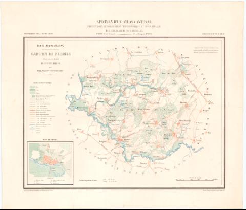
Carte Administrative Canton de Pesures


 Disponible Holdings
 Section: Maps, plans and nautical charts
Uniform title: ALTO SAONA (Francia). Mapas políticos (186). 1:60000
Title: Carte Administrative Canton de Pesures / dressé sous la direction de Mr. Dieu, préfet par Paulin agentvoyer en chef
Material or type of resouce Area: 1:60000
Publication: París : Erhard Schiebe, rue Bonaparte 42, [1860-1869?] (Paris : Imp. Lemercier rue de Seine 57)
Physical description: 1 mapa : col. ; 34 x 45 cm en h. de 46,2 x 53,6 cm
Notes: Comprende el distrito de Gray del departamento de Alto Saona perteneciente a la Región del Franco-Condado
Pertenece al "Spécimen d'un Atlas Cantonal, exécuté dans l'etablissement topographique et Geographique de Erhard Schieble..."
Escala gráfica de 4000 metros [= 6,6 cm]. Coordenadas de la ciudad de Pesures referidas a un meridiano sin especificar
Tabla de signos convencionales para indicar diferentes tipos de vegetación y bosque, divisiones administrativas de distinta categoría, ferrocarriles, calidad de los caminos, puentes, canales, etc
Indica cultivos y masas forestales
En el angulo inferior izquierdo: "Plan de Pesures"
Sello en seco del Depósito General de la Guerra
FRA
FRN
Materia / lugar / evento: Mapas políticos
Divisiones administrativas
Planos de población
Siglo XIX
Pesmes
Francia
UDC: 912:32](44-328 Alto Saona-21-5)'1860/1869'
912:314(44 Pesures) '1860/1869'(084.3)
(44 Pesures)
Type of publication:
 Maps
Maps
Rights:
Préstamo:
Disponible
