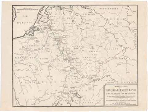
Darstellung der Neutralitataets Linie Welche von...
Section: Maps, plans and nautical charts
Uniform title: Europa. Central. Fronteras (1795). 1:400000
Title: Darstellung der Neutralitataets Linie Welche von Frankreich und Preussen un der am 17 May 1795 zu Basef unterrzeichpet en Convention verabredet Worden : den Beryderseitigen Bevollmaechtigten Gewidmet
Material or type of resouce Area: Escala [ca. 1:400000], 20 Deutsche Meilen [= 7,2 cm]
Publication: Basel [Basilea] : Wilhelm Haas dem Sohne (Typogr. ... der Konigl Preussischen Kademie der Mechanischen Kunste Mitghed), 1795)
Physical description: 1 mapa ; 35x43,4 cm en h. de 38,3x51 cm
Content type: Imagen cartográfica
Media type: computadora
Carrier type: recurso en línea
Notes: Comprende el N.E. de Francia, N. de Suiza, Belgica y Alemania
Indica divisiones administrativas
Materia / lugar / evento: Fronteras
Tratados de paz
Topónimos antiguos
1795
Francia
Bélgica
Alemania
Prusia
Suiza
Other authors: Haas, Wilhelm
Alemania. Koniglch Preussischen Akademie der Mechanischen Klinste Mitghed
UDC: 912:341.222]:341.241(4-191.2)'1795'
Type of publication:
![]() Maps
Maps
Préstamo:
![]() Disponible
Disponible


