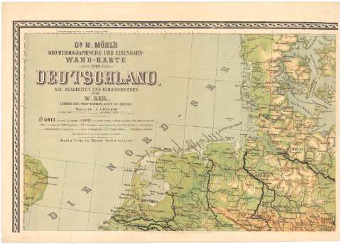
Dr. H. Mohl's Oro - Hydrographische und Eisenbahn - Wand...


 Maps, plans and nautical charts
Dr. H. Mohl's Oro - Hydrographische und Eisenbahn - Wand - Karte von Deutschland (1883 ?)
Maps, plans and nautical charts
Dr. H. Mohl's Oro - Hydrographische und Eisenbahn - Wand - Karte von Deutschland (1883 ?)
 Disponible Holdings
 Section: Maps, plans and nautical charts
Uniform title: Europa. Central. Mapas generales (1883). 1:1000000
Title: Dr. H. Mohl's Oro - Hydrographische und Eisenbahn - Wand - Karte von Deutschland / neu bearbeitet und herdusgegeben von W. Keil, Lehrer der prov. Taubst. Anst. Zu Erfurt Maasstab 1:1000000
Material or type of resouce Area: Escala 1:1000000
Publication: In Cassel : Druck n. Verlag von Theodor Fischer, [1883 ?]
Physical description: 1 mapa en 6 h. : col. ; 147x151,2 cm ó menos en h. de 56,2x79,2 cm ó menos
Content type: Imagen cartográfica
Media type: computadora
Carrier type: recurso en línea
Notes: Comprende Alemania, Suiza, Bélgica, Paises Bajos, Austria, parte de Francia, Checoslovaquia, Polonia y parte norte de Italia y Yugoslavia
Escala grafica de 10 millas geográficas [= 7,2 cm] y 60 kilómetros [= 5,8 cm]. Coordenadas referidas al meridiano de Paris (O2°10'-E21°00'/N55°30'-N42°45') y referidas al meridiano de Hierro (E20°35'-E38°20'/N55°30'-N42°45'). Red geográfica de 1° en 1°
Relieve representado por sombreado
Tabla de signos convencionales para indicar núcleos de población de distinta categoria, fortificaciones, fronteras, lineas ferroviarias, terrenos pantanosos y glaciares
Materia / lugar / evento: Mapas generales
Fortificaciones
Fronteras
Líneas ferroviarias
1883
Alemania
Suiza
Países Bajos
Austria
Other authors: Keil, W
Fischer, Theodor
UDC: 912:551.43]:[623.2:341.222:625.1](4-191.2)'1883'
(4 94)
(492)
(436)
Type of publication:
Maps
Rights:
Préstamo:
Disponible
