Grundriss von Hamburg nebst Umgebung


Section: Maps, plans and nautical charts
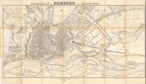
Uniform title: HAMBURGO (Alemania). Planos de población (1845). 1:6000
Title: Grundriss von Hamburg nebst Umgebung / A.A.M. Nagel ; Gedruckt in der lith : Anst. V. Chs. Fuchs ; Nach den neusteu Mefsungen unter Leitung des beeidigteu Geometers A.A.M. Nagel zusammeugetragen von E. Schultse
Material or type of resouce Area: Escala 1:6000
Publication: Berlin : Lithographirt V Himmelheber & Meyer, 1845
Physical description: 1 plano ; 60x115 cm en h. de 68x118 cm
Content type: Imagen cartográfica
Media type: computadora
Carrier type: recurso en línea
Notes: Escala gráfica de 3000 Fufs hambg. [19,5 cm]
Orientado con lis en rosa de 4 vientos
Indica el curso del rio Elba con flecha y campos de cultivo
Entelado en 21 cuartenones
Sello en seco de 'Ban Deputation'
Procede de la 'Colección Rico y Sinobas'
Materia / lugar / evento: Planos de población
1845
Other authors: Nagel, A.A.M
Schultse, E
Fuchs, Ch
Himmelheber & Meyer
UDC: 912:314(430 Hamburgo)'1845'(084.3)(430 Hamburgo)'1845'
430 Hamburgo
Type of publication:
 Maps
Maps
Rights:
Préstamo:
 Disponible
