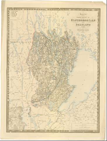
Karta ofver Norra Delen af Elfsborgslan eller Dalsland


 Disponible Holdings
 Section: Maps, plans and nautical charts
Uniform title: SUECIA. SO. Mapas generales (1856). 1:200000
Title: Karta ofver Norra Delen af Elfsborgslan eller Dalsland / Grav. af L. Bernhardt och C.S. Wennersten
Material or type of resouce Area: Escala [ca. 1:200000], 2 Mil [= 10,4 cm] ; [proyec. cónica]
Publication: [Stockholm ?] : utgifven af Topografiska Corpsen, 1856
Physical description: 1 mapa : col. ; 73,5x54,5 cm en h. de 82,5x62,5 cm
Content type: Imagen cartográfica
Media type: computadora
Carrier type: recurso en línea
Notes: Coordenadas referidas, al parecer, al meridiano de Hierro (E29#00'-E30#45'/N59#25'-N58#15') y a otro meridiano que no se específica. Red geográfica de 30' en 30'
Relieve representado por normales y sombreado
Relación de los principales distritos o zonas indicados por clave numérica
Tabla de signos convencionales para indicar núcleos de población de diferente categoría, iglesias, carreteras, faros etc...
En el margen inferior derecho, 'Geogr. langden ar raknad fran Stocholms Observatorium, belaget 35#43'19', 5 ost fran Ferro', 'Siffrorne pa Kartan utnarka hojden ofver hafvet i fot'
Indica límites de divisiones administrativas a color
Inserta : Amal. - Escala [ca. 1:20000]
Materia / lugar / evento: Mapas generales
Divisiones administrativas
1856
Amal
Vanersborg
Other authors: Bernhardt, L
Wennersten, C.S
UDC: 912(485-15)'1856'
(485 Amal)
(485 Vanersborg)
Type of publication:
 Maps
Maps
Rights:
Préstamo:
Disponible
