Nova Europa


Section: Maps, plans and nautical charts
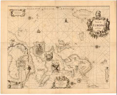
Uniform title: Europa. Mapas generales (1670). 1:7400000
Title: Nova Europa / Pascaarte Nieuwelyx mytgegeven Hugo Allardt tot Amsterdam inde Colver - Straet inde Werldt Caert
Material or type of resouce Area: Escala [ca. 1:7400000], 80 Duytsche mylen 15 voor een graadt [= 8 cm]
Publication: [Amsterdam ? : [Editor no identificado]], 1670
Physical description: 1 mapa : montado sobre tela ; 71x87 cm en h. de 81x100 cm pleg. en 51,5x82 cm
Content type: Imagen cartográfica
Media type: computadora
Carrier type: recurso en línea
Notes: Presenta además un plano del mediterraneo Este.
Escalas graficas de 90 'Spaansche my len 17 1/2 voon een graadt' [= 7,5 cm] y '80 Duytsche mylen 15 voor een graadt' [= 8 cm]
Orientado con lis en rosa de 16 vientos
Indica toponimia en costa y batimetria
Titulo enmarcado barroco al igual que la mención de responsabilidad y la escala representación de escudos, animales y galera en el mapa
Other authors: Allard, Hugo
UDC: 912:551.468(4)'1670'
(6-17)
Type of publication:
 Maps
Maps
Rights:
Préstamo:
 Disponible
