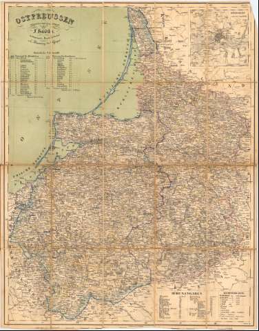
Ostpreussen : entworfen und gezeichnet


 Disponible Holdings
 Section: Maps, plans and nautical charts
Uniform title: Polonia. Mapas generales (1845-1860). 1:475000
Title: Ostpreussen : entworfen und gezeichnet / von F. Handtke
Material or type of resouce Area: Escala 1:475000 ; [proyec. cónica]
Publication: Glogau : Lithographie Druck u. Verlag v. C. Flemming, [1845-1860 ?]
Physical description: 1 mapa : col., montado sobre tela ; 69x53,5 cm, pleg. en 17,3x10,5 cm
Content type: Imagen cartográfica
Media type: computadora
Carrier type: recurso en línea
Notes: Coordenadas referidas al meridiano de Hierro (E37°00'-E40°30'/N55°55'-N53°10') y al meridiano de Paris (E16°55'-E20°35'/N55°55'-N53°10'). Red geográfica de 30' en 30'
Relieve representado por normales y sombreado
Tabla de signos convencionales para indicar núcleos de población de diferente categoría, fuertes, iglesias, carreteras, límites de distritos y pantanos
Relación de las regiones de Konigsberg y de Gumbinnen indicadas por clave numérica y cromática
Relación de las principales poblaciones indicando altitudes
Inserta : Konigsberg und seine Umgebung. - Escala 1:125000
Indica título al verso, en carpetilla : 'Karte der Provinz Ostoreussen, entworfen von F. Handtke Glogan, Druck un Verlag von C. Flemming'
Entelado en 20 cuarterones
Materia / lugar / evento: Mapas generales
Topónimos antiguos
S.XIX
Kaliningrado
Gdansk
Other authors: Handtke, Friedrich H, 1815-1879
Flemming, Carl
UDC: 912(438-17)'1845/1860'
(474.5 Kaliningrad)
(438 Gdansk)
Type of publication:
 Maps
Maps
Rights:
Préstamo:
Disponible
