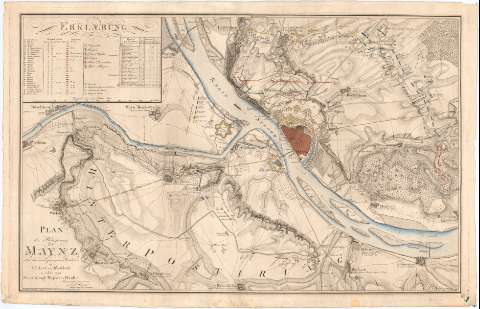
Plan der Belagerung von Maynz nebst den vorhergegangenen...


 Maps, plans and nautical charts
Plan der Belagerung von Maynz nebst den vorhergegangenen Positionen bey Wickert und Hochheim in Jahr 1793 (1794)
Maps, plans and nautical charts
Plan der Belagerung von Maynz nebst den vorhergegangenen Positionen bey Wickert und Hochheim in Jahr 1793 (1794)
 Disponible Holdings
 Section: Maps, plans and nautical charts
Title: Plan der Belagerung von Maynz nebst den vorhergegangenen Positionen bey Wickert und Hochheim in Jahr 1793 / Allerunterthanigst gewidmet von C.J. Humbert... aufgenomen vom J. Lieut. Jachnick und Humbert 1793
Material or type of resouce Area: Escala [ca. 1:35000], 5000 Schritte [= 23,5 cm]
Publication: Berlin : gestochen von Carl Jack, 1794
Physical description: 1 mapa : col. ; 55,3x88,3 cm en h. de 60x94,6 cm
Content type: Imagen cartográfica
Media type: computadora
Carrier type: recurso en línea
Notes: Bajo el titulo : 'Seiner Konigl. Majestat. v. Preussen'
Relieve representado por normales
Relación de las principales fortificaciones, trincheras, baterías etc, indicadas por clave numérica y cromática
Indica las posiciones de los ejércitos por clave cromática y el curso del río Rhin con flecha
Materia / lugar / evento: Guerras
Operaciones bélicas
Estrategia militar
1793
Other authors: Jachnick, J
Jaeck, Carl
Humbert, C.J
UDC: 912:[355.4:355.43](430-2 Maguncia)'1794'
430-2 Maguncia
Type of publication:
Maps
Rights:
Préstamo:
Disponible
