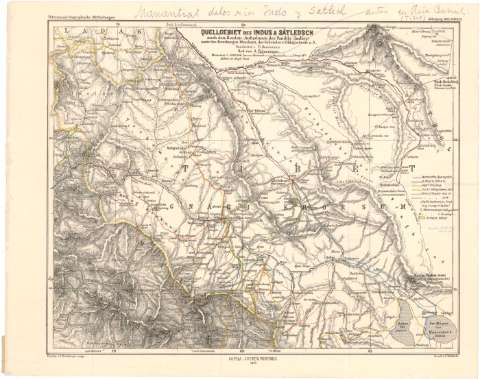
Quellgebiet des Indus & Satledsch nach den Routen -...


 Maps, plans and nautical charts
Quellgebiet des Indus & Satledsch nach den Routen - Aufnahmen der Pandits (Indier)... (1871)
Maps, plans and nautical charts
Quellgebiet des Indus & Satledsch nach den Routen - Aufnahmen der Pandits (Indier)... (1871)
 Disponible Holdings
 Section: Maps, plans and nautical charts
Uniform title: Tibet. Mapas generales (1871). 1:1000000
Title: Quellgebiet des Indus & Satledsch nach den Routen - Aufnahmen der Pandits (Indier)... / Bearbeitet v. Fr. Hanemann ; Terrain v. G. Breithaupt autogr.
Material or type of resouce Area: Escala 1:1000000 ; [proyec. cónica] (E78°35'-E81°40'/N32°45'-N30°35')
Publication: Gotha : Justus Perthes, 1871 (Druck v. Hell - farth)
Physical description: 1 mapa : col. ; 24'6x30'5 cm en h. de 27'7x35 cm
Content type: Imagen cartográfica
Media type: computadora
Carrier type: recurso en línea
Notes: Comprende la región del Tibet y la cordillera del Himalaya
Pertenece al 'Petermann's Geographische Mitteilungen, Jahrgang 1871, Tafel 20'
Escala gráfica de 4 millas geográficas [= 3 cm]. Red geográfica de 1° en 1°
Relieve representado por normales
Tabla de signos convencionales para indicar distintos itinerarios, regiones inglesas etc
Anotaciones manuscritas por Francisco Coello
Procede de la 'Colección Coello'
Materia / lugar / evento: Mapas generales
Itinerarios
1871
Himalaya
Other authors: Breithaupt, G
Hanemann, Fritz, 1847-1877
Perthes, Justus, 1749-1816
Hellfarth, C
UDC: 912:656.02(510-328 Tibet)'1871'
(23.25 Himalaya)
Type of publication:
Maps
Rights:
Préstamo:
Disponible
