Alava


Section: Maps, plans and nautical charts
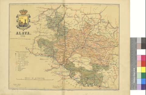
Uniform title: Álava. Mapas generales. 1902. Español. 1:290.000
Title: Alava / Benito Chias, Ing. ; Jqn. Ribera, D. ; J. Soler G.
Material or type of resouce Area: Escala [ca. 1:285.714]
Publication: Barcelona : Alberto Martin, 1902
Physical description: 1 mapa : col. ; 38 x 51 cm, pleg. en 38 x 26 cm
Content type: Imagen cartográfica
Media type: computadora
Carrier type: recurso en línea
Notes: Coordenadas referidas al meridiano de Madrid (E 0 00'-E 1 30'/N 43 16'-N 42 28'). Figuran además latitud y longitud de la capital de provincia y cooordenadas horarias
Relieve representado por normales
Representados límites de partidos judiciales
Ilustrado con el escudo provincial
Figura impresa, la firma del autor
Other titles: En: Atlas Geográfico Ibero-Americano. - Barcelona : Alberto Martín, Muntaner num. 24, 1901-1903
Materia / lugar / evento: Mapas generales
Partidos judiciales
Redes de transporte
Telegrafía
Diócesis
País Vasco
Álava
Other authors: Chías y Carbó, Benito. Atlas Geográfico Ibero-Americano. España. Español
Ribera, Joaquín
Soler, J
UDC: 912:[262.3+654.1](466.3-37)'1902'
(460.156)
Type of publication:
 Maps
Maps
Rights:
Préstamo:
 Disponible
