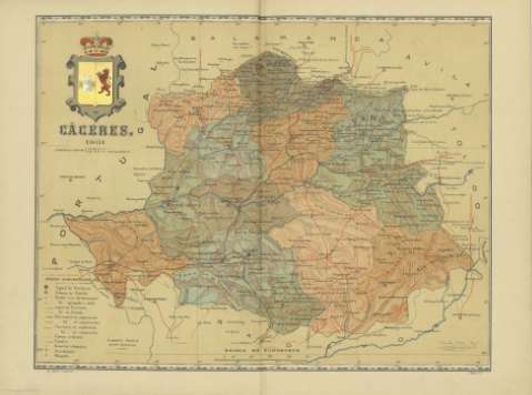
Cáceres


Section: Maps, plans and nautical charts
Uniform title: Cáceres (Provincia). Mapas generales. 1901. Español. 1:580.000
Title: Cáceres / Benito Chias, Ing. ; Jqn. Ribera, D. ; J. Mas G.
Material or type of resouce Area: Escala [1:581.395]
Publication: Barcelona : Alberto Martin, 1901
Physical description: 1 mapa : col. ; 38 x 51 cm, pleg. en 38 x 26 cm
Content type: Imagen cartográfica
Media type: computadora
Carrier type: recurso en línea
Notes: Firmado y rubricado por los autores
Coordenadas: (O 4º-O 1º10'/N 40º35'-N 39º). Meridiano de Madrid
Relieve representado por normales
Señala los límites de los partidos judiciales
Indica las características de los detalles del mapa
Other titles: En: Atlas Geográfico Ibero-Americano. - Barcelona : Alberto Martín, Muntaner num. 24, 1901-1903
Materia / lugar / evento: Mapas generales
Partidos judiciales
Redes de transporte
Telegrafía
Diócesis
Cáceres (Provincia)
Other authors: Chías y Carbó, Benito. Atlas Geográfico Ibero-Americano. España. Español
Ribera, Joaquín
Mas, J
UDC: (460.251)
Type of publication:
 Maps
Maps
Rights:
Préstamo:
 Disponible
