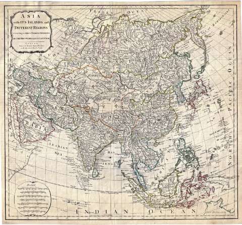
Asia with its islands, an different regions : according...


 Maps, plans and nautical charts
Asia with its islands, an different regions : according to their Modern Divisions, also the Discoveries made by... (1789.03.02)
Maps, plans and nautical charts
Asia with its islands, an different regions : according to their Modern Divisions, also the Discoveries made by... (1789.03.02)
 Disponible Holdings
 Section: Maps, plans and nautical charts
Title: Asia with its islands, an different regions : according to their Modern Divisions, also the Discoveries made by Capt. Cook
Material or type of resouce Area: [Ca. 1:24.400.000]
Publication: London : Printed for Robert Sayer, Fleet Street, as the Act directs, 1789.03.02
Physical description: 1 mapa : col. ; 48 x 52 cm
Content type: Imagen cartográfica
Media type: computadora
Carrier type: recurso en línea
Notes: En los ángulos superior e inferior izquierdos, cartelas conteniendo título y pie de imprenta una de ellas y las escalas gráficas la otra
Escalas gráficas de 1000 millas inglesas de 69 1/2 al grado [= 6,6 cm], 600 millas arábigas, 1000 millas turcas, 300 parasanges persas, 1500 verstas rusas, 800 "coss indias" y 3000 lises chinas. Coordenadas referidas al meridiano de Hierro (E 40°-E 200°/N 74°-S 20°). Red geográfica de 5° en 5°
Relieve de perfil
Señala las fronteras diferenciadas por colores
Reproducción digital
Genre / form: Documentos archivísticos
Mapas generales
Other authors: Sayer, Robert, 1725-1794
España. Dirección de Hidrografía, productor. Expediciones a Indias
Museo Naval (Madrid). Archivo. Documentos gráficos, Mapas
Type of publication:
Maps
Rights:
Préstamo:
Disponible
