Tampa Bay to New Orleans : compiled from surveys made by...


 Maps, plans and nautical charts
Tampa Bay to New Orleans : compiled from surveys made by order of the United Estates Government (1886)
Maps, plans and nautical charts
Tampa Bay to New Orleans : compiled from surveys made by order of the United Estates Government (1886)
 Disponible Holdings
 Section: Maps, plans and nautical charts
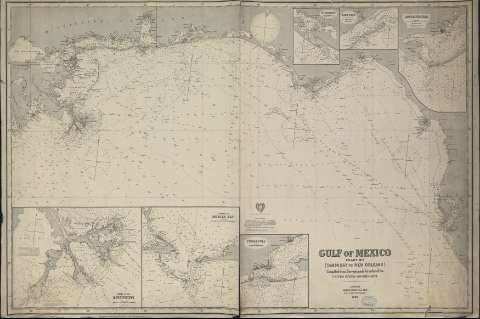
Title: Tampa Bay to New Orleans : compiled from surveys made by order of the United Estates Government / Compiled by James F. Imray, F.R.G.S.
Material or type of resouce Area: Escala [ca. 1:613.074] ( (O 90°20'--O 82°20'/N 30°50'--N 26°20')
Publication: London, 89 and 102 Minories : Published by James Imray and Son, 1886
Physical description: 1 carta náutica ; 85 x 128
Content type: Imagen cartográfica
Media type: computadora
Carrier type: recurso en línea
Series: (Gulf of México. Chart n°I)
Notes: Indica las sondas marinas, faros y alcance de su luz, características del fondo marino, localizaciones dudosas y toponimia costera
Cinco diagramas de declinación magnética
Escala hallada según la equivalencia de un arco de meridiano [=18,1 cm]
Inserta : Carta náutica de la desembocadura del Río Mississippi. Escala [ca. 1:154321]. Carta náutica de la entrada a la Bahía de Mobile. Escala [ca. 1:86806]. Carta náutica desde Pensacola a Warrington. Escala [ca. 1:108933]. Carta náutica del estrecho de Saint George. Escala [ca. 1:154321]. Carta náutica de la isla Dog y alrededores. Escala [ca. 1: 163399]. Carta náutica de la entrada a la bahía de Saint Andrew. Escala [ca. 1:115741]. Todos ellos con diagrama de declinación magnética
Sello de los editores en el ángulo inferior derecho
En el verso : Etiqueta de los editores con el nombre, serie, precio... y un reborde con información sobre algunos de los lugares representados
Materia / lugar / evento: Cartas náuticas
Florida
Alabama
Mississippi
Luisiana (Estados Unidos, Estado)
Estados Unidos
México (Golfo)
Other authors: Imray, James F., 1829?-1891
UDC: 912.551.46]:627.715(73-12)"1886"
73-12
Type of publication:
Maps
Rights:
Préstamo:
Disponible
