A Map of the British Colonies in North America : with the...


 Maps, plans and nautical charts
A Map of the British Colonies in North America : with the Roads, Distances, limits an Extent of the Seattlements... (1755)
Maps, plans and nautical charts
A Map of the British Colonies in North America : with the Roads, Distances, limits an Extent of the Seattlements... (1755)
 Disponible Holdings
 Section: Maps, plans and nautical charts
Uniform title: Estados Unidos. Colonias (1775). 1:2004460
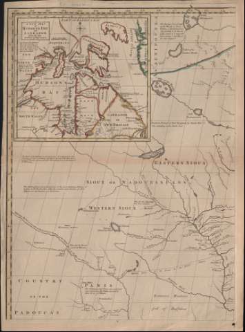
Title: A Map of the British Colonies in North America : with the Roads, Distances, limits an Extent of the Seattlements... / By their Lordships..., John Mitchell
Material or type of resouce Area: Escala [ca. 1:2.004.460]
Publication: [London] : The author, 1755 (London, Charing Cross : Jeferys and Faden)
Physical description: 1 mapa en 8 hoja ; hoja 71 x 52 cm
Content type: Imagen cartográfica
Media type: computadora
Carrier type: recurso en línea
Notes: Escalas gráficas de 180 millas, 208 1/2 millas inglesas, 60 leguas marinas inglesas y francesas, 75 leguas francesas comunes, y 45 millas alemanas [= 16,7 cm]
Inserta mapa de la bahía de Hudson y Labrador en ángulo superior izquierdo de la hoja 4
Leyenda acerca de las condiciones administrativas en que se realizó el mapa
Tablas de observaciones astronómicas, latitudes y longitudes
Materia / lugar / evento: Colonias
Estados Unidos
Other authors: Mitchell, John, 1711-1768
Jefferys, Thomas, ca. 1710-1771
Faden, William, 1749-1836
UDC: 912:325.3(73)
73
Type of publication:
Maps
Rights:
Préstamo:
Disponible
