To the Right Honorable George Grenville Esqr. First Lord...


 Maps, plans and nautical charts
To the Right Honorable George Grenville Esqr. First Lord Commissioner of the Treasury, Chancellor and under... (1763)
Maps, plans and nautical charts
To the Right Honorable George Grenville Esqr. First Lord Commissioner of the Treasury, Chancellor and under... (1763)
 Disponible Holdings
 Section: Maps, plans and nautical charts
Uniform title: JAMAICA. Mapas generales. 1763. 1:90668
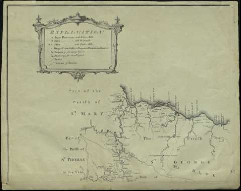
Title: To the Right Honorable George Grenville Esqr. First Lord Commissioner of the Treasury, Chancellor and under Treasurer of the Exchequer, This Map of the County of Surry in the Island of Jamaica / (laid down from the Papers and under the direction of Henry Moore Esqr. His Majesty's Lieutenant Governor, and Commander in Chief of that Island in the Years 1756-57-58-59-60 and 61 from a great Number of Actual Surveys performed by the Publishers) is humbly Inscribed by ... Thos. Craskell, Engineeer, Jas. Simpson, Surveyor
Material or type of resouce Area: Scale [ca. 1:90.668]. 12 miles [= 21,3 cm]
Publication: Londini : Dal. Fournier direxit, 1763
Physical description: 1 mapa en 4 h. : grab. ; en h. de 54 x 65 cm
Content type: Imagen cartográfica
Media type: computadora
Carrier type: recurso en línea
Notes: Orientado con rosa de 8 vientos y lis
Indica veriles, bajos, fondeaderos y sondas batimétricas
Tabla de signos convencionales para indicar plantaciones de azúcar, fondeaderos, caminos, divisiones administrativas, etc.
Título enmarcado en cartela barroca con escena costumbrista
Escala representada en conjunto arquictectónico con figuras mitológicas
Materia / lugar / evento: Mapas generales
Divisiones administrativas
Jamaica
Other authors: Simpson, James, s. XVIII
Fournier, Daniel
Craskell, Thomas
UDC: 729.2
Type of publication:
Maps
Rights:
Préstamo:
Disponible
