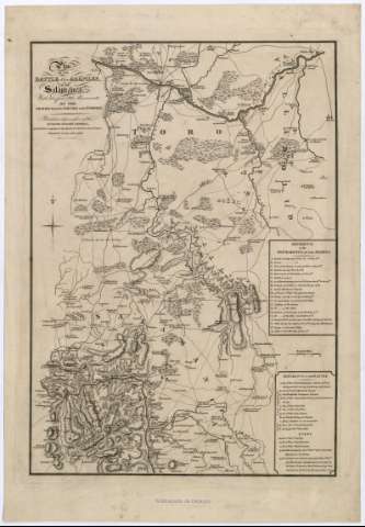
Plan of the Battle of the Arapiles, near Salamanca : with...


 Maps, plans and nautical charts
Plan of the Battle of the Arapiles, near Salamanca : with the previons movements of the Armies from the Douro to... (Jan. 1-1813)
Maps, plans and nautical charts
Plan of the Battle of the Arapiles, near Salamanca : with the previons movements of the Armies from the Douro to... (Jan. 1-1813)
 Disponible Holdings
 Section: Maps, plans and nautical charts
Title: Plan of the Battle of the Arapiles, near Salamanca : with the previons movements of the Armies from the Douro to the Tormes / Thompson sculpt
Material or type of resouce Area: Escala [ca. 1:184.000]. 4 millas inglesas [=3,5 cm]
Publication: [London] : Published... by W. Faden, Geographer to his Majesty & to H.R.H. the Prince Regent, Charing Cross, Jan. 1-1813
Physical description: 1 mapa : montado sobre tela ; 48 x 34 cm
Content type: Imagen cartográfica
Media type: computadora
Carrier type: recurso en línea
Notes: Comprende la parte nororiental de la provincia de Salamanca, suroccidental de Valladolid y suroriental de Zamora
Orientado con lis en rosa de ocho vientos
Relieve representado por normales
Relación de los movimientos de los ejércitos indicada mediante clave alfabética
Leyenda explicativa sobre el desarrollo de la batalla
Materia / lugar / evento: Batalla de los Arapiles, 1812
España - Historia - 1808-1814 (Guerra de la Independencia)
Genre / form: Mapas militares
Other authors: Faden, William, 1749-1836
UDC: 912:355.43:355.4(462.13-18)(462.12-12)(463.1-14)"1813"
462.13-18
462.12-12
463.1-14
Type of publication:
Maps
Rights:
Préstamo:
Disponible
