Planisphère Terrestre suivant la projection de Mercator :...


 Maps, plans and nautical charts
Planisphère Terrestre suivant la projection de Mercator : principaux itinéraires maritimes et de découvertes... (1867)
Maps, plans and nautical charts
Planisphère Terrestre suivant la projection de Mercator : principaux itinéraires maritimes et de découvertes... (1867)
 Disponible Holdings
 Section: Maps, plans and nautical charts
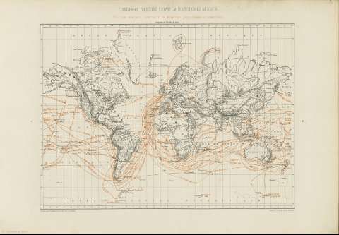
Title: Planisphère Terrestre suivant la projection de Mercator : principaux itinéraires maritimes et de découvertes géographiques et scientifiques / dressé par A. Vuillemin ; sous la dirn. de J. A. Barral ; gravé par S. Jacobs et Isid. Dalmour
Material or type of resouce Area: Escala [ca. 1:37037036 - ca. 1:111111110] 1 [= 0'3 - 0'1 cm] ; proye. de mercator
Publication: Paris : [Gide, 1867]
Physical description: 1 mapamundi : col. ; 33x49 cm + 2 p.
Content type: Imagen cartográfica
Media type: computadora
Carrier type: recurso en línea
Notes: Márgenes graduados
Relieve por montes de perfil y sombreado
Hidrografía
Toponimia
Datos de publicación tomados de la obra que contiene el mapa
Copia digital. España : Ministerio de Cultura. Dirección General del Libro, Archivos y Bibliotecas, 2010
Materia / lugar / evento: Mapas físicos
Derroteros
Descubrimientos geográficos
Expediciones geográficas
Tierra
Other authors: Vuillemin, Alexandre, 1812-1880
Barral, Jean Augustine, 1819-1884
Dalmont, Isidore
Gide
UDC: 912:911.2:[527.6+910.4+910.4(21)](100)'1867'
100
Type of publication:
Maps
Rights:
Préstamo:
Disponible
