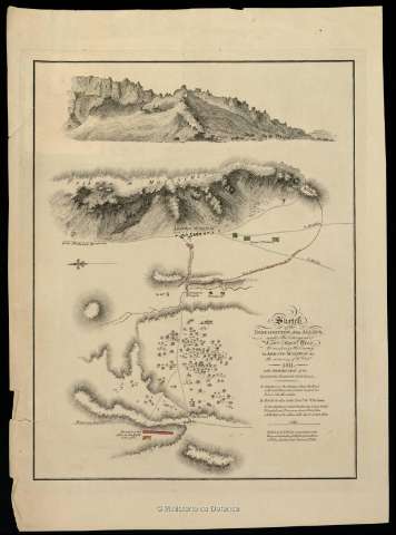
Sketch of the Disposition of the Allies under the Command...


 Maps, plans and nautical charts
Sketch of the Disposition of the Allies under the Command of Lient. Genl. Hill to surprize the Enemy in Arroyo...
Maps, plans and nautical charts
Sketch of the Disposition of the Allies under the Command of Lient. Genl. Hill to surprize the Enemy in Arroyo...
 Disponible Holdings
 Section: Maps, plans and nautical charts
Title: Sketch of the Disposition of the Allies under the Command of Lient. Genl. Hill to surprize the Enemy in Arroyo Molinos on the morning of 28th. Oct. 1811 : with Permission of the Quarter Master General
Material or type of resouce Area: Escala [ca. 1:49.000]. 1 milla [=3,8 cm]
Publication: [Londres?] : Published by W. Faden, Geographer to the King..., Charing Cross January 1st. 1812
Physical description: 1 mapa : col. ; 31,2 x 23,7 cm en h. de 43,6 x 28,5 cm
Content type: Imagen cartográfica
Media type: computadora
Carrier type: recurso en línea
Notes: Orientado con lis
Relieve representado por normales
Nota relativa a la destrucción de la división enemiga y prisioneros
Relación de la posición de los ejércitos indicados mediante clave cromática
Materia / lugar / evento: Batallas
Estratègia militar
Arroyomolinos (Cáceres)
Nombre jerárquico lugar: España - Extremadura - Cáceres - Arroyomolinos de Montánchez
Other authors: Faden, William, 1749-1836
Related titles: Cáceres (Provincia). Mapas generales (1811?). 1:45.000
UDC: 460.251 Arroyomolinos de Montánchez
Type of publication:
Maps
Rights:
Préstamo:
Disponible
Préstamo:
Disponible
