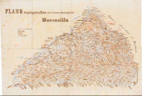
Plano topografico del Termino Municipal de Manzanillo


 Disponible Holdings
 Section: Maps, plans and nautical charts
Title: Plano topografico del Termino Municipal de Manzanillo
Material or type of resouce Area: Escala indeterminada
Physical description: 1 mapa : ms., col., en tela para planos ; 83'6 x 121'8 cm, pleg. en 42'0 x 25'0 cm
Content type: Imagen cartográfica
Media type: computadora
Carrier type: recurso en línea
Notes: Comprende el área entre Manzanillo, Cabo Cruz y Punta Turquino.
Fecha tomada de : "Catálogo de Mapas y Planos. Cuba" del SGE, 1974.
Relieve representado por curvas de configuración
Tabla de signos convencionales para indicar las estaciones y líneas telefónicas, potreros, centrales, caminos y ríos
Delineado con varias tintas
Pertenece a un cuadernilllo titulado : "Mapas de las Juridicciones de Cuba, Manzanillo, Cobre, Cabo-Cruz y Holguin" [sic]
Materia / lugar / evento: Mapas generales
Comunicaciones
UDC: 912:383/388(729.16-14)"1880/1881"
729.16-14
Type of publication:
 Maps
Maps
Rights:
Préstamo:
Disponible
